Richterswil geodata
Richterswil (Zurich) is a populated place; located in Switzerland in Europe/Zurich (GMT+2) time zone. With population of 10,189 people, there are 144 cities with bigger population in this country. Compared to other cities in Switzerland, 52% of cities are located further ↑North; 74% of cities are located further ←West and 51.5% of cities have lower elevation than Richterswil. Note1


Richterswil GPS coordinates[2]
47° 12' 22.392" North, 8° 41' 48.696" East
| Map corner | latitude | longitude |
|---|---|---|
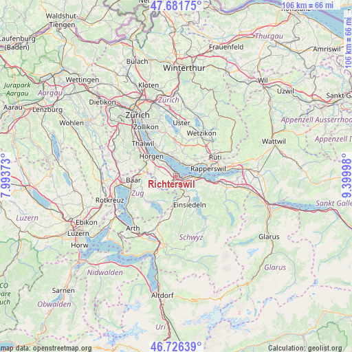
| Upper-left | 47.68175°, | 7.99373° |
| Center: | 47.20622°, | 8.69686° |
| Lower-right: | 46.72639°, | 9.39998° |
| Map W x H: | 106.2×106.2 km | = 66×66mi |
| max Lat: | 47.76737° ⇑52% North |
| Richterswil: | 47.20622° |
| min Lat: | ⇓48% South 45.83203° |
| min Long | Richterswil | max Long |
| 5.97153° | 8.69686° | 10.44624° |
| W 74%⇐ | ⇒26% E |
Elevation
Elevation of Richterswil is 482 m = 1581 ft, and this is 76.2 m = 250 ft below average elevation for this country.
| Max E: |
1845 m = 6053 ft | 48.5% |
| Avg. | 558.2 m = 1831 ft | |
| Richterswil | 482 m = 1581 ft | |
Min E: |
197 m = 646 ft | 51.5% |
See also: Switzerland elevation on elevation.city.
Geographical zone
Richterswil is located in North temperate zone (between Tropic of Cancer and the Arctic Circle). Distance of this North polar circle is 2152.3 km =1337.4 mi to North.| Distance of | km | miles | from Richterswil |
|---|---|---|---|
| North Pole | 4758.2 | 2956.6 | to North |
| Arctic Circle | 2152.3 | 1337.4 | to North |
| Tropic Cancer | 2642.9 | 1642.2 | to South |
| Equator | 5248.8 | 3261.5 | to South |


Nearby cities:
15 places around Richterswil: (largest is in red/bold)
• Bäch
2.7 km =1.7 mi,  95°
95°
• Feusisberg
4.4 km =2.7 mi,  119°
119°
• Richterswil / Burghalde
0.6 km =0.4 mi,  313°
313°
• Richterswil / Dorfkern
0.7 km =0.4 mi,  81°
81°
• Richterswil / Richterswil (Dorfkern)
0.7 km =0.4 mi, 117°
• Samstagern
2 km =1.2 mi,  214°
214°
• Schindellegi
3.7 km =2.3 mi,  160°
160°
• Wollerau
2.1 km =1.3 mi,  127°
127°
• Wädenswil
3.1 km =1.9 mi,  317°
317°
• Wädenswil / Boller-Giessen
1.9 km =1.2 mi,  329°
329°
• Wädenswil / Büelen
4 km =2.5 mi, 320°
• Wädenswil / Dorf (Wädenswil)
3.2 km =2 mi, 323°
• Wädenswil / Eichweid
2.2 km =1.4 mi, 308°
• Wädenswil / Leihof-Mühlebach
2.7 km =1.7 mi, 315°
• Wädenswil / Untermosen-Fuhr
3.5 km =2.2 mi, 313°
Sources, notices
• [Note1] Compared only with cities in Switzerland existing in our database
• [Src1] Map data: © OpenStreetMap contributors (CC-BY-SA)
• [Src2] Other city data from geonames.org with taken over terms of usage.
• [Src3] Geographical zone / Annual Mean Temperature by Robert A. Rohde @ Wikipedia
