Liestal geodata
Liestal (Basel-Landschaft) is a seat of a first-order administrative division; located in Switzerland in Europe/Zurich (GMT+2) time zone. With population of 12,832 people, there are 103 cities with bigger population in this country. Compared to other cities in Switzerland, 86.9% of cities are located further ↓South; 67.5% of cities are located further →East and 96.6% of cities have higher elevation than Liestal. Note1


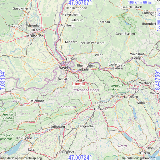
Liestal GPS coordinates[2]
47° 29' 4.38" North, 7° 44' 4.056" East
| Map corner | latitude | longitude |
|---|---|---|
| Upper-left | 47.95757°, | 7.03134° |
| Center: | 47.48455°, | 7.73446° |
| Lower-right: | 47.00724°, | 8.43759° |
| Map W x H: | 105.7×105.7 km | = 65.7×65.7mi |
| max Lat: | 47.76737° ⇑13.1% North |
| Liestal: | 47.48455° |
| min Lat: | ⇓86.9% South 45.83203° |
| min Long | Liestal | max Long |
| 5.97153° | 7.73446° | 10.44624° |
| W 32.5%⇐ | ⇒67.5% E |
Elevation
Elevation of Liestal is 327 m = 1073 ft, and this is 231.2 m = 759 ft below average elevation for this country.
| Max E: |
1845 m = 6053 ft | 96.6% |
| Avg. | 558.2 m = 1831 ft | |
| Liestal | 327 m = 1073 ft | |
Min E: |
197 m = 646 ft | 3.4% |
See also: Switzerland elevation on elevation.city.
Geographical zone
Liestal is located in North temperate zone (between Tropic of Cancer and the Arctic Circle). Distance of this North polar circle is 2121.4 km =1318.2 mi to North.| Distance of | km | miles | from Liestal |
|---|---|---|---|
| North Pole | 4727.3 | 2937.4 | to North |
| Arctic Circle | 2121.4 | 1318.2 | to North |
| Tropic Cancer | 2673.9 | 1661.5 | to South |
| Equator | 5279.8 | 3280.7 | to South |


Nearby cities:
15 places around Liestal: (largest is in red/bold)
• Arisdorf
3.9 km =2.4 mi,  35°
35°
• Augst
5.9 km =3.7 mi,  345°
345°
• Bubendorf
4.3 km =2.7 mi,  176°
176°
• Frenkendorf
2.8 km =1.7 mi,  331°
331°
• Füllinsdorf
2.5 km =1.6 mi, 354°
• Gempen
5.7 km =3.5 mi,  260°
260°
• Hölstein
7.4 km =4.6 mi,  158°
158°
• Itingen
4.3 km =2.7 mi,  117°
117°
• Kaiseraugst
6.2 km =3.9 mi, 354°
• Lausen
2.4 km =1.5 mi,  126°
126°
• Magden
7.6 km =4.7 mi,  49°
49°
• Pratteln
5.1 km =3.2 mi,  322°
322°
• Seltisberg
2.7 km =1.7 mi,  203°
203°
• Sissach
6 km =3.7 mi,  112°
112°
• Zunzgen
6.8 km =4.2 mi, 125°
Sources, notices
• [Note1] Compared only with cities in Switzerland existing in our database
• [Src1] Map data: © OpenStreetMap contributors (CC-BY-SA)
• [Src2] Other city data from geonames.org with taken over terms of usage.
• [Src3] Geographical zone / Annual Mean Temperature by Robert A. Rohde @ Wikipedia
