Kaiseraugst geodata
Kaiseraugst (Aargau) is a populated place; located in Switzerland in Europe/Zurich (GMT+2) time zone. With population of 3,600 people, there are 496 cities with bigger population in this country. Compared to other cities in Switzerland, 94.1% of cities are located further ↓South; 67.7% of cities are located further →East and 98.7% of cities have higher elevation than Kaiseraugst. Note1


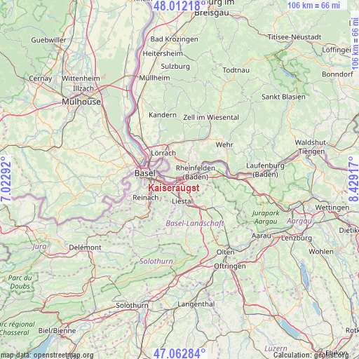
Kaiseraugst GPS coordinates[2]
47° 32' 22.776" North, 7° 43' 33.78" East
| Map corner | latitude | longitude |
|---|---|---|
| Upper-left | 48.01218°, | 7.02292° |
| Center: | 47.53966°, | 7.72605° |
| Lower-right: | 47.06284°, | 8.42917° |
| Map W x H: | 105.6×105.6 km | = 65.6×65.6mi |
| max Lat: | 47.76737° ⇑5.9% North |
| Kaiseraugst: | 47.53966° |
| min Lat: | ⇓94.1% South 45.83203° |
| min Long | Kaiseraugst | max Long |
| 5.97153° | 7.72605° | 10.44624° |
| W 32.3%⇐ | ⇒67.7% E |
Elevation
Elevation of Kaiseraugst is 268 m = 879 ft, and this is 290.2 m = 952 ft below average elevation for this country.
| Max E: |
1845 m = 6053 ft | 98.7% |
| Avg. | 558.2 m = 1831 ft | |
| Kaiseraugst | 268 m = 879 ft | |
Min E: |
197 m = 646 ft | 1.3% |
See also: Switzerland elevation on elevation.city.
Geographical zone
Kaiseraugst is located in North temperate zone (between Tropic of Cancer and the Arctic Circle). Distance of this North polar circle is 2115.3 km =1314.4 mi to North.| Distance of | km | miles | from Kaiseraugst |
|---|---|---|---|
| North Pole | 4721.1 | 2933.6 | to North |
| Arctic Circle | 2115.3 | 1314.4 | to North |
| Tropic Cancer | 2680 | 1665.3 | to South |
| Equator | 5285.9 | 3284.5 | to South |


Nearby cities:
15 places around Kaiseraugst: (largest is in red/bold)
• Arisdorf
4.2 km =2.6 mi,  135°
135°
• Augst
1 km =0.6 mi,  241°
241°
• Bettingen
5.8 km =3.6 mi,  306°
306°
• Birsfelden
7.9 km =4.9 mi,  280°
280°
• Frenkendorf
3.7 km =2.3 mi,  191°
191°
• Füllinsdorf
3.7 km =2.3 mi,  173°
173°
• Gempen
8.6 km =5.3 mi,  214°
214°
• Lausen
8 km =5 mi,  161°
161°
• Liestal
6.2 km =3.9 mi, 174°
• Magden
6.5 km =4 mi,  100°
100°
• Muttenz
6.4 km =4 mi,  252°
252°
• Pratteln
3.2 km =2 mi,  229°
229°
• Rheinfelden
5.4 km =3.4 mi,  72°
72°
• Riehen
7.4 km =4.6 mi, 306°
• Seltisberg
8.6 km =5.3 mi,  182°
182°
Sources, notices
• [Note1] Compared only with cities in Switzerland existing in our database
• [Src1] Map data: © OpenStreetMap contributors (CC-BY-SA)
• [Src2] Other city data from geonames.org with taken over terms of usage.
• [Src3] Geographical zone / Annual Mean Temperature by Robert A. Rohde @ Wikipedia
