Elsau-Räterschen / Räterschen geodata
Elsau-Räterschen / Räterschen (Zurich) is a section of populated place; located in Switzerland in Europe/Zurich (GMT+2) time zone. With population of 1,071 people, there are 1281 cities with bigger population in this country. Compared to other cities in Switzerland, 89% of cities are located further ↓South; 80.9% of cities are located further ←West and 50.3% of cities have higher elevation than Elsau-Räterschen / Räterschen. Note1
Current local time in Elsau-Räterschen / Räterschen:
08:54 AM, SaturdayDifference from your time zone: hours


Elsau-Räterschen / Räterschen GPS coordinates[2]
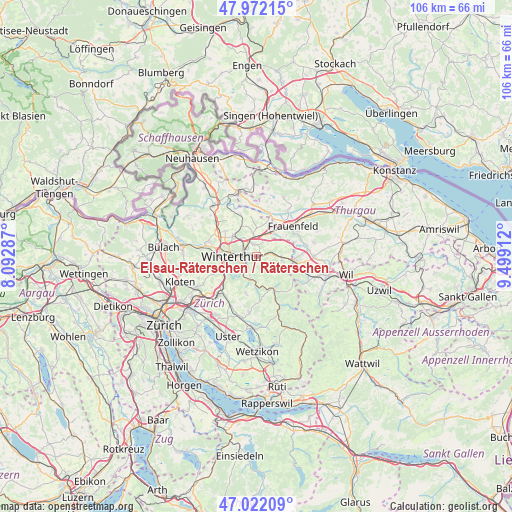
47° 29' 57.372" North, 8° 47' 45.6" East
| Map corner | latitude | longitude |
|---|---|---|
| Upper-left | 47.97215°, | 8.09287° |
| Center: | 47.49927°, | 8.796° |
| Lower-right: | 47.02209°, | 9.49912° |
| Map W x H: | 105.6×105.6 km | = 65.6×65.6mi |
| max Lat: | 47.76737° ⇑11% North |
| Elsau-Räterschen / Räterschen: | 47.49927° |
| min Lat: | ⇓89% South 45.83203° |
| min Long | Elsau-Rätersch | max Long |
| 5.97153° | 8.796° | 10.44624° |
| W 80.9%⇐ | ⇒19.1% E |
Elevation
Elevation of Elsau-Räterschen / Räterschen is 477 m = 1565 ft, and this is 81.2 m = 266 ft below average elevation for this country.
| Max E: |
1845 m = 6053 ft | 50.3% |
| Avg. | 558.2 m = 1831 ft | |
| Elsau-Räterschen / Räterschen | 477 m = 1565 ft | |
Min E: |
197 m = 646 ft | 49.7% |
See also: Switzerland elevation on elevation.city.
Geographical zone
Elsau-Räterschen / Räterschen is located in North temperate zone (between Tropic of Cancer and the Arctic Circle). Distance of this North polar circle is 2119.8 km =1317.2 mi to North.| Distance of | km | miles | from Elsau-Räterschen / Räterschen |
|---|---|---|---|
| North Pole | 4725.6 | 2936.4 | to North |
| Arctic Circle | 2119.8 | 1317.2 | to North |
| Tropic Cancer | 2675.5 | 1662.5 | to South |
| Equator | 5281.4 | 3281.7 | to South |


Nearby cities:
15 places around Elsau-Räterschen / Räterschen: (largest is in red/bold)
• Elsau-Räterschen
0.4 km =0.2 mi,  30°
30°
• Oberwinterthur (Kreis 2)
2.8 km =1.7 mi,  313°
313°
• Oberwinterthur (Kreis 2) / Grüze
2.9 km =1.8 mi,  267°
267°
• Oberwinterthur (Kreis 2) / Guggenbühl
3.1 km =1.9 mi,  300°
300°
• Oberwinterthur (Kreis 2) / Hegi
2.1 km =1.3 mi,  294°
294°
• Oberwinterthur (Kreis 2) / Hegmatten
2.8 km =1.7 mi, 295°
• Rümikon
0.7 km =0.4 mi, 297°
• Schottikon
1.4 km =0.9 mi,  91°
91°
• Seen (Kreis 3)
3.2 km =2 mi,  217°
217°
• Seen (Kreis 3) / Büelwiesen
2.8 km =1.7 mi,  234°
234°
• Seen (Kreis 3) / Ganzenbühl
3.2 km =2 mi, 231°
• Seen (Kreis 3) / Oberseen
2.6 km =1.6 mi, 222°
• Seen (Kreis 3) / Sonnenberg
2.2 km =1.4 mi,  240°
240°
• Seen (Kreis 3) / Waser
2.9 km =1.8 mi,  247°
247°
• Wiesendangen / Wiesendangen (Dorf)
2.5 km =1.6 mi,  349°
349°
Sources, notices
• [Note1] Compared only with cities in Switzerland existing in our database
• [Src1] Map data: © OpenStreetMap contributors (CC-BY-SA)
• [Src2] Other city data from geonames.org with taken over terms of usage.
• [Src3] Geographical zone / Annual Mean Temperature by Robert A. Rohde @ Wikipedia
