Rafz geodata
Rafz (Zurich) is a populated place; located in Switzerland in Europe/Zurich (GMT+2) time zone. With population of 3,233 people, there are 545 cities with bigger population in this country. Compared to other cities in Switzerland, 97.4% of cities are located further ↓South; 61% of cities are located further ←West and 80.1% of cities have higher elevation than Rafz. Note1


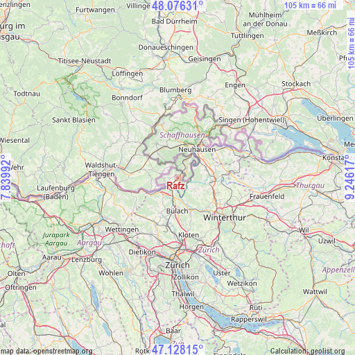
Rafz GPS coordinates[2]
47° 36' 15.768" North, 8° 32' 34.98" East
| Map corner | latitude | longitude |
|---|---|---|
| Upper-left | 48.07631°, | 7.83992° |
| Center: | 47.60438°, | 8.54305° |
| Lower-right: | 47.12815°, | 9.24617° |
| Map W x H: | 105.4×105.4 km | = 65.5×65.5mi |
| max Lat: | 47.76737° ⇑2.6% North |
| Rafz: | 47.60438° |
| min Lat: | ⇓97.4% South 45.83203° |
| min Long | Rafz | max Long |
| 5.97153° | 8.54305° | 10.44624° |
| W 61%⇐ | ⇒39% E |
Elevation
Elevation of Rafz is 421 m = 1381 ft, and this is 137.2 m = 450 ft below average elevation for this country.
| Max E: |
1845 m = 6053 ft | 80.1% |
| Avg. | 558.2 m = 1831 ft | |
| Rafz | 421 m = 1381 ft | |
Min E: |
197 m = 646 ft | 19.9% |
See also: Switzerland elevation on elevation.city.
Geographical zone
Rafz is located in North temperate zone (between Tropic of Cancer and the Arctic Circle). Distance of this North polar circle is 2108.1 km =1309.9 mi to North.| Distance of | km | miles | from Rafz |
|---|---|---|---|
| North Pole | 4714 | 2929.1 | to North |
| Arctic Circle | 2108.1 | 1309.9 | to North |
| Tropic Cancer | 2687.2 | 1669.7 | to South |
| Equator | 5293.1 | 3289 | to South |


Nearby cities:
15 places around Rafz: (largest is in red/bold)
• Buchberg
3.8 km =2.4 mi,  157°
157°
• Bülach / Chröpfli
8.5 km =5.3 mi,  177°
177°
• Dorf
8.6 km =5.3 mi,  114°
114°
• Eglisau
3.4 km =2.1 mi,  208°
208°
• Flaach
5.7 km =3.5 mi,  123°
123°
• Freienstein
8.5 km =5.3 mi, 158°
• Glattfelden
6 km =3.7 mi, 211°
• Hüntwangen
4 km =2.5 mi,  256°
256°
• Marthalen / Dorfkern
8.3 km =5.2 mi,  73°
73°
• Neu-Rheinau
5.9 km =3.7 mi,  55°
55°
• Rorbas
8.5 km =5.3 mi, 163°
• Seglingen
3.9 km =2.4 mi, 205°
• Seglingen / Ober-Seglingen
3.8 km =2.4 mi,  198°
198°
• Wasterkingen
5.6 km =3.5 mi,  252°
252°
• Wil
2.6 km =1.6 mi,  270°
270°
Sources, notices
• [Note1] Compared only with cities in Switzerland existing in our database
• [Src1] Map data: © OpenStreetMap contributors (CC-BY-SA)
• [Src2] Other city data from geonames.org with taken over terms of usage.
• [Src3] Geographical zone / Annual Mean Temperature by Robert A. Rohde @ Wikipedia
