Seglingen geodata
Seglingen (Zurich) is a populated place; located in Switzerland in Europe/Zurich (GMT+2) time zone. With population of 1,144 people, there are 1236 cities with bigger population in this country. Compared to other cities in Switzerland, 96% of cities are located further ↓South; 58.3% of cities are located further ←West and 93% of cities have higher elevation than Seglingen. Note1


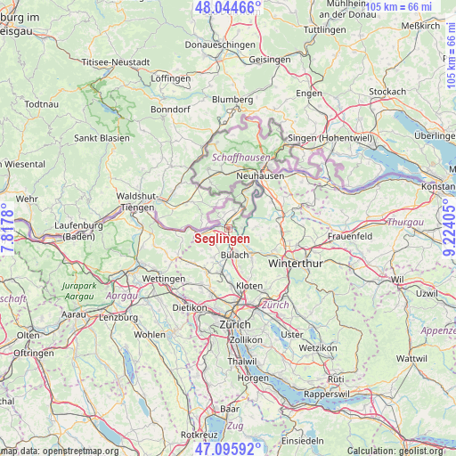
Seglingen GPS coordinates[2]
47° 34' 20.784" North, 8° 31' 15.348" East
| Map corner | latitude | longitude |
|---|---|---|
| Upper-left | 48.04466°, | 7.8178° |
| Center: | 47.57244°, | 8.52093° |
| Lower-right: | 47.09592°, | 9.22405° |
| Map W x H: | 105.5×105.5 km | = 65.6×65.6mi |
| max Lat: | 47.76737° ⇑4% North |
| Seglingen: | 47.57244° |
| min Lat: | ⇓96% South 45.83203° |
| min Long | Seglingen | max Long |
| 5.97153° | 8.52093° | 10.44624° |
| W 58.3%⇐ | ⇒41.7% E |
Elevation
Elevation of Seglingen is 379 m = 1243 ft, and this is 179.2 m = 588 ft below average elevation for this country.
| Max E: |
1845 m = 6053 ft | 93% |
| Avg. | 558.2 m = 1831 ft | |
| Seglingen | 379 m = 1243 ft | |
Min E: |
197 m = 646 ft | 7% |
See also: Switzerland elevation on elevation.city.
Geographical zone
Seglingen is located in North temperate zone (between Tropic of Cancer and the Arctic Circle). Distance of this North polar circle is 2111.6 km =1312.1 mi to North.| Distance of | km | miles | from Seglingen |
|---|---|---|---|
| North Pole | 4717.5 | 2931.3 | to North |
| Arctic Circle | 2111.6 | 1312.1 | to North |
| Tropic Cancer | 2683.6 | 1667.5 | to South |
| Equator | 5289.6 | 3286.8 | to South |


Nearby cities:
15 places around Seglingen: (largest is in red/bold)
• Buchberg
3.1 km =1.9 mi,  89°
89°
• Bülach
5.8 km =3.6 mi,  165°
165°
• Bülach / Chröpfli
5.3 km =3.3 mi,  158°
158°
• Bülach / Grossstein
5.9 km =3.7 mi, 171°
• Bülach / Gstückt
5.8 km =3.6 mi, 159°
• Bülach / Herti
6.1 km =3.8 mi, 168°
• Bülach / Soligänter
5.3 km =3.3 mi, 163°
• Eglisau
0.5 km =0.3 mi,  2°
2°
• Glattfelden
2.1 km =1.3 mi,  223°
223°
• Hochfelden
5.6 km =3.5 mi,  184°
184°
• Hüntwangen
3.4 km =2.1 mi,  319°
319°
• Rafz
3.9 km =2.4 mi,  25°
25°
• Seglingen / Ober-Seglingen
0.5 km =0.3 mi,  96°
96°
• Wasterkingen
4.2 km =2.6 mi,  297°
297°
• Wil
3.7 km =2.3 mi,  344°
344°
Sources, notices
• [Note1] Compared only with cities in Switzerland existing in our database
• [Src1] Map data: © OpenStreetMap contributors (CC-BY-SA)
• [Src2] Other city data from geonames.org with taken over terms of usage.
• [Src3] Geographical zone / Annual Mean Temperature by Robert A. Rohde @ Wikipedia
