Urtenen geodata
Urtenen (Bern) is a populated place; located in Switzerland in Europe/Zurich (GMT+2) time zone. With population of 5,258 people, there are 321 cities with bigger population in this country. Compared to other cities in Switzerland, 63.1% of cities are located further ↑North; 75.4% of cities are located further →East and 61.4% of cities have lower elevation than Urtenen. Note1
Administrative division(s):
- Level 1: Bern
- Level 2: Bern-Mittelland District
- Level 3: Urtenen-Schönbühl


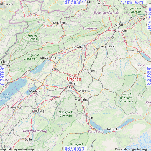
Urtenen GPS coordinates[2]
47° 1' 36.012" North, 7° 30' 2.916" East
| Map corner | latitude | longitude |
|---|---|---|
| Upper-left | 47.50381°, | 6.79769° |
| Center: | 47.02667°, | 7.50081° |
| Lower-right: | 46.54523°, | 8.20394° |
| Map W x H: | 106.6×106.6 km | = 66.2×66.2mi |
| max Lat: | 47.76737° ⇑63.1% North |
| Urtenen: | 47.02667° |
| min Lat: | ⇓36.9% South 45.83203° |
| min Long | Urtenen | max Long |
| 5.97153° | 7.50081° | 10.44624° |
| W 24.6%⇐ | ⇒75.4% E |
Elevation
Elevation of Urtenen is 528 m = 1732 ft, and this is 30.2 m = 99 ft below average elevation for this country.
| Max E: |
1845 m = 6053 ft | 38.6% |
| Avg. | 558.2 m = 1831 ft | |
| Urtenen | 528 m = 1732 ft | |
Min E: |
197 m = 646 ft | 61.4% |
See also: Switzerland elevation on elevation.city.
Geographical zone
Urtenen is located in North temperate zone (between Tropic of Cancer and the Arctic Circle). Distance of this North polar circle is 2172.3 km =1349.8 mi to North.| Distance of | km | miles | from Urtenen |
|---|---|---|---|
| North Pole | 4778.2 | 2969 | to North |
| Arctic Circle | 2172.3 | 1349.8 | to North |
| Tropic Cancer | 2623 | 1629.9 | to South |
| Equator | 5228.9 | 3249.1 | to South |


Nearby cities:
15 places around Urtenen: (largest is in red/bold)
• Bolligen
5.7 km =3.5 mi,  182°
182°
• Bäriswil
2.1 km =1.3 mi,  111°
111°
• Fraubrunnen
6.9 km =4.3 mi,  16°
16°
• Hindelbank
3.6 km =2.2 mi,  59°
59°
• Jegenstorf
2.4 km =1.5 mi,  12°
12°
• Kirchberg
9 km =5.6 mi,  43°
43°
• Kirchlindach
7 km =4.3 mi,  244°
244°
• Krauchthal
5.3 km =3.3 mi, 110°
• Lyssach
7.5 km =4.7 mi, 55°
• Messen
8.4 km =5.2 mi,  329°
329°
• Münchenbuchsee
3.9 km =2.4 mi,  261°
261°
• Ostermundigen
7.8 km =4.8 mi,  185°
185°
• Rüti bei Lyssach
6.7 km =4.2 mi, 59°
• Stettlen
7.8 km =4.8 mi,  166°
166°
• Zollikofen
4.5 km =2.8 mi,  226°
226°
Sources, notices
• [Note1] Compared only with cities in Switzerland existing in our database
• [Src1] Map data: © OpenStreetMap contributors (CC-BY-SA)
• [Src2] Other city data from geonames.org with taken over terms of usage.
• [Src3] Geographical zone / Annual Mean Temperature by Robert A. Rohde @ Wikipedia
