Neuenhof geodata
Neuenhof (Aargau) is a populated place; located in Switzerland in Europe/Zurich (GMT+2) time zone. With population of 7,957 people, there are 202 cities with bigger population in this country. Compared to other cities in Switzerland, 82.4% of cities are located further ↓South; 52.5% of cities are located further →East and 89.1% of cities have higher elevation than Neuenhof. Note1


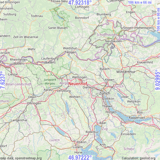
Neuenhof GPS coordinates[2]
47° 26' 59.46" North, 8° 19' 36.552" East
| Map corner | latitude | longitude |
|---|---|---|
| Upper-left | 47.92318°, | 7.6237° |
| Center: | 47.44985°, | 8.32682° |
| Lower-right: | 46.97222°, | 9.02995° |
| Map W x H: | 105.7×105.7 km | = 65.7×65.7mi |
| max Lat: | 47.76737° ⇑17.6% North |
| Neuenhof: | 47.44985° |
| min Lat: | ⇓82.4% South 45.83203° |
| min Long | Neuenhof | max Long |
| 5.97153° | 8.32682° | 10.44624° |
| W 47.5%⇐ | ⇒52.5% E |
Elevation
Elevation of Neuenhof is 398 m = 1306 ft, and this is 160.2 m = 526 ft below average elevation for this country.
| Max E: |
1845 m = 6053 ft | 89.1% |
| Avg. | 558.2 m = 1831 ft | |
| Neuenhof | 398 m = 1306 ft | |
Min E: |
197 m = 646 ft | 10.9% |
See also: Switzerland elevation on elevation.city.
Geographical zone
Neuenhof is located in North temperate zone (between Tropic of Cancer and the Arctic Circle). Distance of this North polar circle is 2125.2 km =1320.5 mi to North.| Distance of | km | miles | from Neuenhof |
|---|---|---|---|
| North Pole | 4731.1 | 2939.8 | to North |
| Arctic Circle | 2125.2 | 1320.5 | to North |
| Tropic Cancer | 2670 | 1659.1 | to South |
| Equator | 5275.9 | 3278.3 | to South |


Nearby cities:
15 places around Neuenhof: (largest is in red/bold)
• Baden
3 km =1.9 mi,  328°
328°
• Birmenstorf
6.1 km =3.8 mi,  282°
282°
• Dänikon
6 km =3.7 mi,  93°
93°
• Dänikon / Bifang
6.1 km =3.8 mi, 92°
• Ehrendingen
6.1 km =3.8 mi,  14°
14°
• Killwangen
2.7 km =1.7 mi,  137°
137°
• Mellingen
5.3 km =3.3 mi,  229°
229°
• Niederrohrdorf
3.3 km =2.1 mi,  210°
210°
• Oberrohrdorf
3.5 km =2.2 mi,  188°
188°
• Obersiggenthal
4.8 km =3 mi, 331°
• Oetwil / Oetwil an der Limmat
5.7 km =3.5 mi,  115°
115°
• Otelfingen
5 km =3.1 mi,  76°
76°
• Spreitenbach
4.3 km =2.7 mi,  134°
134°
• Wettingen
2.4 km =1.5 mi,  341°
341°
• Würenlos
2.8 km =1.7 mi,  107°
107°
Sources, notices
• [Note1] Compared only with cities in Switzerland existing in our database
• [Src1] Map data: © OpenStreetMap contributors (CC-BY-SA)
• [Src2] Other city data from geonames.org with taken over terms of usage.
• [Src3] Geographical zone / Annual Mean Temperature by Robert A. Rohde @ Wikipedia
