Marthalen geodata
Marthalen (Zurich) is a populated place; located in Switzerland in Europe/Zurich (GMT+2) time zone. With population of 1,567 people, there are 998 cities with bigger population in this country. Compared to other cities in Switzerland, 97.8% of cities are located further ↓South; 70.5% of cities are located further ←West and 89.9% of cities have higher elevation than Marthalen. Note1


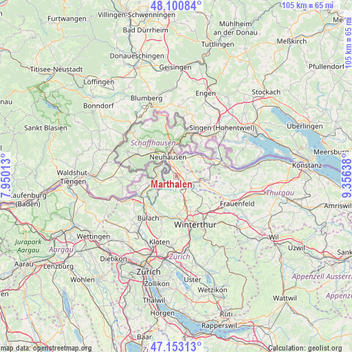
Marthalen GPS coordinates[2]
47° 37' 44.868" North, 8° 39' 11.736" East
| Map corner | latitude | longitude |
|---|---|---|
| Upper-left | 48.10084°, | 7.95013° |
| Center: | 47.62913°, | 8.65326° |
| Lower-right: | 47.15313°, | 9.35638° |
| Map W x H: | 105.4×105.4 km | = 65.5×65.5mi |
| max Lat: | 47.76737° ⇑2.2% North |
| Marthalen: | 47.62913° |
| min Lat: | ⇓97.8% South 45.83203° |
| min Long | Marthalen | max Long |
| 5.97153° | 8.65326° | 10.44624° |
| W 70.5%⇐ | ⇒29.5% E |
Elevation
Elevation of Marthalen is 395 m = 1296 ft, and this is 163.2 m = 535 ft below average elevation for this country.
| Max E: |
1845 m = 6053 ft | 89.9% |
| Avg. | 558.2 m = 1831 ft | |
| Marthalen | 395 m = 1296 ft | |
Min E: |
197 m = 646 ft | 10.1% |
See also: Switzerland elevation on elevation.city.
Geographical zone
Marthalen is located in North temperate zone (between Tropic of Cancer and the Arctic Circle). Distance of this North polar circle is 2105.3 km =1308.2 mi to North.| Distance of | km | miles | from Marthalen |
|---|---|---|---|
| North Pole | 4711.2 | 2927.4 | to North |
| Arctic Circle | 2105.3 | 1308.2 | to North |
| Tropic Cancer | 2689.9 | 1671.4 | to South |
| Equator | 5295.9 | 3290.7 | to South |


Nearby cities:
15 places around Marthalen: (largest is in red/bold)
• Andelfingen
4.3 km =2.7 mi,  154°
154°
• Benken
2.6 km =1.6 mi,  1°
1°
• Dachsen
4.8 km =3 mi,  326°
326°
• Dorf
6.3 km =3.9 mi,  183°
183°
• Feuerthalen
6.9 km =4.3 mi,  353°
353°
• Flaach
6.9 km =4.3 mi,  210°
210°
• Flurlingen
6.3 km =3.9 mi,  344°
344°
• Kleinandelfingen
3.9 km =2.4 mi,  144°
144°
• Langwiesen
6.1 km =3.8 mi,  5°
5°
• Marthalen / Dorfkern
0.5 km =0.3 mi,  215°
215°
• Neu-Rheinau
3.4 km =2.1 mi,  279°
279°
• Neuhausen
6.9 km =4.3 mi, 335°
• Ossingen
5.9 km =3.7 mi,  109°
109°
• Trüllikon
2.8 km =1.7 mi,  75°
75°
• Uhwiesen
4.8 km =3 mi, 343°
Sources, notices
• [Note1] Compared only with cities in Switzerland existing in our database
• [Src1] Map data: © OpenStreetMap contributors (CC-BY-SA)
• [Src2] Other city data from geonames.org with taken over terms of usage.
• [Src3] Geographical zone / Annual Mean Temperature by Robert A. Rohde @ Wikipedia
