Ossingen geodata
Ossingen (Zurich) is a populated place; located in Switzerland in Europe/Zurich (GMT+2) time zone. With population of 959 people, there are 1363 cities with bigger population in this country. Compared to other cities in Switzerland, 97.7% of cities are located further ↓South; 76.8% of cities are located further ←West and 80.6% of cities have higher elevation than Ossingen. Note1


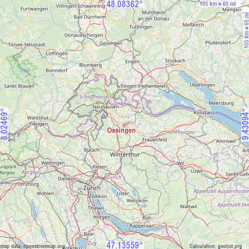
Ossingen GPS coordinates[2]
47° 36' 42.3" North, 8° 43' 40.116" East
| Map corner | latitude | longitude |
|---|---|---|
| Upper-left | 48.08362°, | 8.02469° |
| Center: | 47.61175°, | 8.72781° |
| Lower-right: | 47.13559°, | 9.43094° |
| Map W x H: | 105.4×105.4 km | = 65.5×65.5mi |
| max Lat: | 47.76737° ⇑2.3% North |
| Ossingen: | 47.61175° |
| min Lat: | ⇓97.7% South 45.83203° |
| min Long | Ossingen | max Long |
| 5.97153° | 8.72781° | 10.44624° |
| W 76.8%⇐ | ⇒23.2% E |
Elevation
Elevation of Ossingen is 420 m = 1378 ft, and this is 138.2 m = 453 ft below average elevation for this country.
| Max E: |
1845 m = 6053 ft | 80.6% |
| Avg. | 558.2 m = 1831 ft | |
| Ossingen | 420 m = 1378 ft | |
Min E: |
197 m = 646 ft | 19.4% |
See also: Switzerland elevation on elevation.city.
Geographical zone
Ossingen is located in North temperate zone (between Tropic of Cancer and the Arctic Circle). Distance of this North polar circle is 2107.2 km =1309.4 mi to North.| Distance of | km | miles | from Ossingen |
|---|---|---|---|
| North Pole | 4713.1 | 2928.6 | to North |
| Arctic Circle | 2107.2 | 1309.4 | to North |
| Tropic Cancer | 2688 | 1670.2 | to South |
| Equator | 5293.9 | 3289.5 | to South |


Nearby cities:
15 places around Ossingen: (largest is in red/bold)
• Andelfingen
4.2 km =2.6 mi,  242°
242°
• Benken
7.2 km =4.5 mi,  309°
309°
• Dinhard
6.9 km =4.3 mi,  155°
155°
• Dorf
7.4 km =4.6 mi,  234°
234°
• Henggart
6.4 km =4 mi,  212°
212°
• Hettlingen
7.5 km =4.7 mi,  193°
193°
• Hettlingen / Dorfkern
7.4 km =4.6 mi, 192°
• Hettlingen / Gübel
7.2 km =4.5 mi, 187°
• Kleinandelfingen
3.5 km =2.2 mi,  249°
249°
• Marthalen
5.9 km =3.7 mi,  289°
289°
• Marthalen / Dorfkern
6.1 km =3.8 mi,  284°
284°
• Oberneuforn
3 km =1.9 mi,  104°
104°
• Oberstammheim
5.9 km =3.7 mi,  66°
66°
• Trüllikon
3.9 km =2.4 mi, 312°
• Unterstammheim
5.6 km =3.5 mi,  57°
57°
Sources, notices
• [Note1] Compared only with cities in Switzerland existing in our database
• [Src1] Map data: © OpenStreetMap contributors (CC-BY-SA)
• [Src2] Other city data from geonames.org with taken over terms of usage.
• [Src3] Geographical zone / Annual Mean Temperature by Robert A. Rohde @ Wikipedia
