Andelfingen geodata
Andelfingen (Zurich) is a seat of a second-order administrative division; located in Switzerland in Europe/Zurich (GMT+2) time zone. With population of 1,328 people, there are 1117 cities with bigger population in this country. Compared to other cities in Switzerland, 96.9% of cities are located further ↓South; 72.3% of cities are located further ←West and 89.1% of cities have higher elevation than Andelfingen. Note1


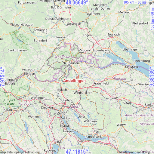
Andelfingen GPS coordinates[2]
47° 35' 40.092" North, 8° 40' 41.736" East
| Map corner | latitude | longitude |
|---|---|---|
| Upper-left | 48.06649°, | 7.97514° |
| Center: | 47.59447°, | 8.67826° |
| Lower-right: | 47.11815°, | 9.38139° |
| Map W x H: | 105.4×105.4 km | = 65.5×65.5mi |
| max Lat: | 47.76737° ⇑3.1% North |
| Andelfingen: | 47.59447° |
| min Lat: | ⇓96.9% South 45.83203° |
| min Long | Andelfingen | max Long |
| 5.97153° | 8.67826° | 10.44624° |
| W 72.3%⇐ | ⇒27.7% E |
Elevation
Elevation of Andelfingen is 398 m = 1306 ft, and this is 160.2 m = 526 ft below average elevation for this country.
| Max E: |
1845 m = 6053 ft | 89.1% |
| Avg. | 558.2 m = 1831 ft | |
| Andelfingen | 398 m = 1306 ft | |
Min E: |
197 m = 646 ft | 10.9% |
See also: Switzerland elevation on elevation.city.
Geographical zone
Andelfingen is located in North temperate zone (between Tropic of Cancer and the Arctic Circle). Distance of this North polar circle is 2109.2 km =1310.6 mi to North.| Distance of | km | miles | from Andelfingen |
|---|---|---|---|
| North Pole | 4715.1 | 2929.8 | to North |
| Arctic Circle | 2109.2 | 1310.6 | to North |
| Tropic Cancer | 2686.1 | 1669.1 | to South |
| Equator | 5292 | 3288.3 | to South |


Nearby cities:
15 places around Andelfingen: (largest is in red/bold)
• Benken
6.7 km =4.2 mi,  344°
344°
• Dorf
3.3 km =2.1 mi,  223°
223°
• Flaach
5.8 km =3.6 mi,  249°
249°
• Henggart
3.5 km =2.2 mi,  175°
175°
• Hettlingen
5.7 km =3.5 mi,  159°
159°
• Hettlingen / Dorfkern
5.7 km =3.5 mi, 157°
• Hettlingen / Gübel
5.9 km =3.7 mi,  151°
151°
• Kleinandelfingen
0.8 km =0.5 mi,  30°
30°
• Marthalen
4.3 km =2.7 mi,  334°
334°
• Marthalen / Dorfkern
4.1 km =2.5 mi, 328°
• Neu-Rheinau
6.9 km =4.3 mi,  310°
310°
• Oberneuforn
6.8 km =4.2 mi,  80°
80°
• Ossingen
4.2 km =2.6 mi,  62°
62°
• Seuzach Dorf / Pünten-Ifang
7.4 km =4.6 mi, 148°
• Trüllikon
4.6 km =2.9 mi,  10°
10°
Sources, notices
• [Note1] Compared only with cities in Switzerland existing in our database
• [Src1] Map data: © OpenStreetMap contributors (CC-BY-SA)
• [Src2] Other city data from geonames.org with taken over terms of usage.
• [Src3] Geographical zone / Annual Mean Temperature by Robert A. Rohde @ Wikipedia
