Feuerthalen geodata
Feuerthalen (Zurich) is a populated place; located in Switzerland in Europe/Zurich (GMT+2) time zone. With population of 2,165 people, there are 788 cities with bigger population in this country. Compared to other cities in Switzerland, 99.3% of cities are located further ↓South; 69.7% of cities are located further ←West and 81.7% of cities have higher elevation than Feuerthalen. Note1


Feuerthalen GPS coordinates[2]
47° 41' 25.944" North, 8° 38' 36.852" East
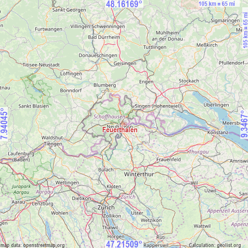
| Map corner | latitude | longitude |
|---|---|---|
| Upper-left | 48.16169°, | 7.94045° |
| Center: | 47.69054°, | 8.64357° |
| Lower-right: | 47.21509°, | 9.3467° |
| Map W x H: | 105.3×105.3 km | = 65.4×65.4mi |
| max Lat: | 47.76737° ⇑0.7% North |
| Feuerthalen: | 47.69054° |
| min Lat: | ⇓99.3% South 45.83203° |
| min Long | Feuerthalen | max Long |
| 5.97153° | 8.64357° | 10.44624° |
| W 69.7%⇐ | ⇒30.3% E |
Elevation
Elevation of Feuerthalen is 418 m = 1371 ft, and this is 140.2 m = 460 ft below average elevation for this country.
| Max E: |
1845 m = 6053 ft | 81.7% |
| Avg. | 558.2 m = 1831 ft | |
| Feuerthalen | 418 m = 1371 ft | |
Min E: |
197 m = 646 ft | 18.3% |
See also: Switzerland elevation on elevation.city.
Geographical zone
Feuerthalen is located in North temperate zone (between Tropic of Cancer and the Arctic Circle). Distance of this North polar circle is 2098.5 km =1303.9 mi to North.| Distance of | km | miles | from Feuerthalen |
|---|---|---|---|
| North Pole | 4704.4 | 2923.2 | to North |
| Arctic Circle | 2098.5 | 1303.9 | to North |
| Tropic Cancer | 2696.8 | 1675.7 | to South |
| Equator | 5302.7 | 3294.9 | to South |


Nearby cities:
15 places around Feuerthalen: (largest is in red/bold)
• Benken
4.3 km =2.7 mi,  169°
169°
• Beringen
5.2 km =3.2 mi,  278°
278°
• Dachsen
3.4 km =2.1 mi,  214°
214°
• Dörflingen
6.1 km =3.8 mi,  73°
73°
• Flurlingen
1.3 km =0.8 mi,  234°
234°
• Hemmental
6.5 km =4 mi,  317°
317°
• Langwiesen
1.5 km =0.9 mi,  119°
119°
• Löhningen
6.9 km =4.3 mi, 279°
• Marthalen
6.9 km =4.3 mi, 173°
• Neu-Rheinau
6.8 km =4.2 mi,  202°
202°
• Neuhausen
2.2 km =1.4 mi,  256°
256°
• Schaffhausen
1 km =0.6 mi, 319°
• Stetten
5.7 km =3.5 mi,  14°
14°
• Trüllikon
7 km =4.3 mi,  150°
150°
• Uhwiesen
2.3 km =1.4 mi, 195°
Sources, notices
• [Note1] Compared only with cities in Switzerland existing in our database
• [Src1] Map data: © OpenStreetMap contributors (CC-BY-SA)
• [Src2] Other city data from geonames.org with taken over terms of usage.
• [Src3] Geographical zone / Annual Mean Temperature by Robert A. Rohde @ Wikipedia
