Palézieux geodata
Palézieux (Vaud) is a populated place; located in Switzerland in Europe/Zurich (GMT+2) time zone. With population of 1,209 people, there are 1192 cities with bigger population in this country. Compared to other cities in Switzerland, 84% of cities are located further ↑North; 90.9% of cities are located further →East and 81.6% of cities have lower elevation than Palézieux. Note1


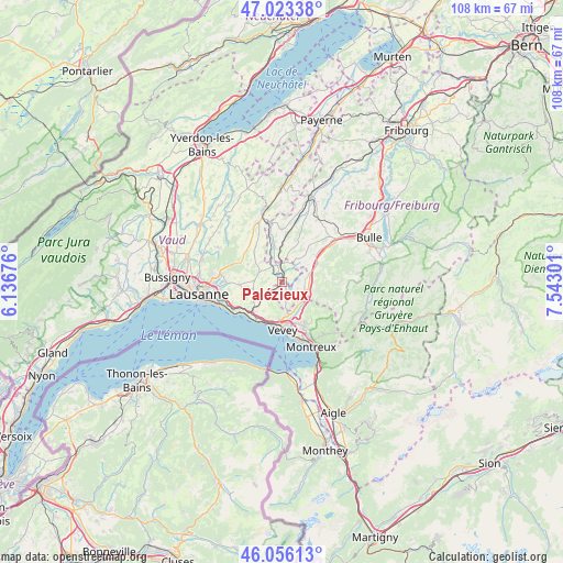
Palézieux GPS coordinates[2]
46° 32' 30.876" North, 6° 50' 23.604" East
| Map corner | latitude | longitude |
|---|---|---|
| Upper-left | 47.02338°, | 6.13676° |
| Center: | 46.54191°, | 6.83989° |
| Lower-right: | 46.05613°, | 7.54301° |
| Map W x H: | 107.5×107.5 km | = 66.8×66.8mi |
| max Lat: | 47.76737° ⇑84% North |
| Palézieux: | 46.54191° |
| min Lat: | ⇓16% South 45.83203° |
| min Long | Palézieux | max Long |
| 5.97153° | 6.83989° | 10.44624° |
| W 9.1%⇐ | ⇒90.9% E |
Elevation
Elevation of Palézieux is 684 m = 2244 ft, and this is 125.8 m = 413 ft above average elevation for this country.
| Max E: |
1845 m = 6053 ft | 18.4% |
| Palézieux | 684 m 2244 ft | |
| Avg. | 558.2 m = 1831 ft | |
Min E: |
197 m = 646 ft | 81.6% |
See also: Switzerland elevation on elevation.city.
Geographical zone
Palézieux is located in North temperate zone (between Tropic of Cancer and the Arctic Circle). Distance of this North polar circle is 2226.2 km =1383.3 mi to North.| Distance of | km | miles | from Palézieux |
|---|---|---|---|
| North Pole | 4832.1 | 3002.5 | to North |
| Arctic Circle | 2226.2 | 1383.3 | to North |
| Tropic Cancer | 2569.1 | 1596.4 | to South |
| Equator | 5175 | 3215.6 | to South |


Nearby cities:
15 places around Palézieux: (largest is in red/bold)
• Attalens
4.1 km =2.5 mi,  168°
168°
• Chardonne
7.3 km =4.5 mi,  187°
187°
• Chexbres
8.2 km =5.1 mi,  215°
215°
• Châtel-Saint-Denis
5 km =3.1 mi,  109°
109°
• Ecublens
7.7 km =4.8 mi,  341°
341°
• Jongny
7 km =4.3 mi,  179°
179°
• Maracon
2.6 km =1.6 mi,  69°
69°
• Oron-la-Ville
3.4 km =2.1 mi, 341°
• Puidoux
6.3 km =3.9 mi, 223°
• Rue
8.7 km =5.4 mi,  351°
351°
• Saint Saphorin
8.3 km =5.2 mi,  203°
203°
• Savigny
8.2 km =5.1 mi,  267°
267°
• Semsales
7.7 km =4.8 mi,  63°
63°
• Servion
5.7 km =3.5 mi,  304°
304°
• St-Légier-La Chiésaz
8.2 km =5.1 mi,  161°
161°
Sources, notices
• [Note1] Compared only with cities in Switzerland existing in our database
• [Src1] Map data: © OpenStreetMap contributors (CC-BY-SA)
• [Src2] Other city data from geonames.org with taken over terms of usage.
• [Src3] Geographical zone / Annual Mean Temperature by Robert A. Rohde @ Wikipedia
