Ballaigues geodata
Ballaigues (Vaud) is a populated place; located in Switzerland in Europe/Zurich (GMT+2) time zone. With population of 849 people, there are 1457 cities with bigger population in this country. Compared to other cities in Switzerland, 77.4% of cities are located further ↑North; 96.4% of cities are located further →East and 92% of cities have lower elevation than Ballaigues. Note1


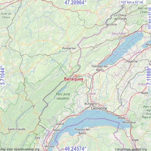
Ballaigues GPS coordinates[2]
46° 43' 47.424" North, 6° 24' 48.852" East
| Map corner | latitude | longitude |
|---|---|---|
| Upper-left | 47.20964°, | 5.71044° |
| Center: | 46.72984°, | 6.41357° |
| Lower-right: | 46.24574°, | 7.11669° |
| Map W x H: | 107.2×107.2 km | = 66.6×66.6mi |
| max Lat: | 47.76737° ⇑77.4% North |
| Ballaigues: | 46.72984° |
| min Lat: | ⇓22.6% South 45.83203° |
| min Long | Ballaigues | max Long |
| 5.97153° | 6.41357° | 10.44624° |
| W 3.6%⇐ | ⇒96.4% E |
Elevation
Elevation of Ballaigues is 878 m = 2881 ft, and this is 319.8 m = 1049 ft above average elevation for this country.
| Max E: |
1845 m = 6053 ft | 8% |
| Ballaigues | 878 m 2881 ft | |
| Avg. | 558.2 m = 1831 ft | |
Min E: |
197 m = 646 ft | 92% |
See also: Switzerland elevation on elevation.city.
Geographical zone
Ballaigues is located in North temperate zone (between Tropic of Cancer and the Arctic Circle). Distance of this North polar circle is 2205.3 km =1370.3 mi to North.| Distance of | km | miles | from Ballaigues |
|---|---|---|---|
| North Pole | 4811.2 | 2989.5 | to North |
| Arctic Circle | 2205.3 | 1370.3 | to North |
| Tropic Cancer | 2590 | 1609.4 | to South |
| Equator | 5195.9 | 3228.6 | to South |


Nearby cities:
15 places around Ballaigues: (largest is in red/bold)
• Baulmes
10.7 km =6.6 mi,  51°
51°
• Bavois
12.8 km =8 mi,  113°
113°
• Chavornay
12.3 km =7.6 mi,  104°
104°
• Chevilly
10.8 km =6.7 mi,  153°
153°
• Cuarnens
11.7 km =7.3 mi,  171°
171°
• Ferreyres
9.7 km =6 mi, 145°
• L'Abbaye
11.5 km =7.1 mi,  218°
218°
• La Sarraz
10.8 km =6.7 mi,  136°
136°
• Les Clées
3.7 km =2.3 mi,  86°
86°
• Moiry
9.5 km =5.9 mi,  161°
161°
• Orbe
8.9 km =5.5 mi, 93°
• Orny
11 km =6.8 mi,  128°
128°
• Pompaples
10.1 km =6.3 mi, 133°
• Sainte-Croix
12.3 km =7.6 mi,  33°
33°
• Vallorbe
3.3 km =2.1 mi,  233°
233°
Sources, notices
• [Note1] Compared only with cities in Switzerland existing in our database
• [Src1] Map data: © OpenStreetMap contributors (CC-BY-SA)
• [Src2] Other city data from geonames.org with taken over terms of usage.
• [Src3] Geographical zone / Annual Mean Temperature by Robert A. Rohde @ Wikipedia
