Kollbrunn geodata
Kollbrunn (Zurich) is a populated place; located in Switzerland in Europe/Zurich (GMT+1) time zone. With population of 1,848 people, there are 889 cities with bigger population in this country. Compared to other cities in Switzerland, 83.6% of cities are located further ↓South; 80.3% of cities are located further ←West and 61.2% of cities have lower elevation than Kollbrunn. Note1


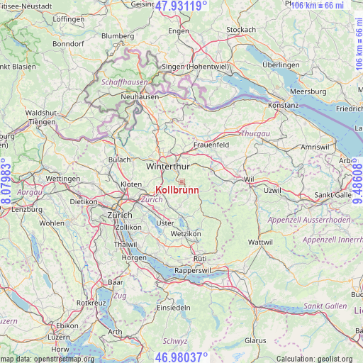
Kollbrunn GPS coordinates[2]
47° 27' 28.548" North, 8° 46' 58.62" East
| Map corner | latitude | longitude |
|---|---|---|
| Upper-left | 47.93119°, | 8.07983° |
| Center: | 47.45793°, | 8.78295° |
| Lower-right: | 46.98037°, | 9.48608° |
| Map W x H: | 105.7×105.7 km | = 65.7×65.7mi |
| max Lat: | 47.76737° ⇑16.4% North |
| Kollbrunn: | 47.45793° |
| min Lat: | ⇓83.6% South 45.83203° |
| min Long | Kollbrunn | max Long |
| 5.97153° | 8.78295° | 10.44624° |
| W 80.3%⇐ | ⇒19.7% E |
Elevation
Elevation of Kollbrunn is 526 m = 1726 ft, and this is 32.2 m = 106 ft below average elevation for this country.
| Max E: |
1845 m = 6053 ft | 38.8% |
| Avg. | 558.2 m = 1831 ft | |
| Kollbrunn | 526 m = 1726 ft | |
Min E: |
197 m = 646 ft | 61.2% |
See also: Switzerland elevation on elevation.city.
Geographical zone
Kollbrunn is located in North temperate zone (between Tropic of Cancer and the Arctic Circle). Distance of this North polar circle is 2124.3 km =1320 mi to North.| Distance of | km | miles | from Kollbrunn |
|---|---|---|---|
| North Pole | 4730.2 | 2939.2 | to North |
| Arctic Circle | 2124.3 | 1320 | to North |
| Tropic Cancer | 2670.9 | 1659.6 | to South |
| Equator | 5276.8 | 3278.9 | to South |


Nearby cities:
15 places around Kollbrunn: (largest is in red/bold)
• Kollbrunn / Kollbrunn (Dorfkern)
0.7 km =0.4 mi,  265°
265°
• Mattenbach (Kreis 7)
4.2 km =2.6 mi,  320°
320°
• Mattenbach (Kreis 7) / Endliker
4.2 km =2.6 mi, 323°
• Rikon / Rikon (Dorfkern)
1.8 km =1.1 mi,  139°
139°
• Rämismühle
3.6 km =2.2 mi,  125°
125°
• Seen (Kreis 3)
2.3 km =1.4 mi,  334°
334°
• Seen (Kreis 3) / Büelwiesen
3.2 km =2 mi,  335°
335°
• Seen (Kreis 3) / Ganzenbühl
3 km =1.9 mi, 329°
• Seen (Kreis 3) / Iberg
0.9 km =0.6 mi, 332°
• Seen (Kreis 3) / Oberseen
2.8 km =1.7 mi, 344°
• Seen (Kreis 3) / Sennhof
2.2 km =1.4 mi,  300°
300°
• Seen (Kreis 3) / Sonnenberg
3.6 km =2.2 mi, 344°
• Seen (Kreis 3) / Waldegg
3.5 km =2.2 mi, 324°
• Seen (Kreis 3) / Waser
3.9 km =2.4 mi, 333°
• Weisslingen
3.2 km =2 mi,  200°
200°
Sources, notices
• [Note1] Compared only with cities in Switzerland existing in our database
• [Src1] Map data: © OpenStreetMap contributors (CC-BY-SA)
• [Src2] Other city data from geonames.org with taken over terms of usage.
• [Src3] Geographical zone / Annual Mean Temperature by Robert A. Rohde @ Wikipedia
