Rämismühle geodata
Rämismühle (Zurich) is a populated place; located in Switzerland in Europe/Zurich (GMT+2) time zone. With population of 505 people, there are 1799 cities with bigger population in this country. Compared to other cities in Switzerland, 80.8% of cities are located further ↓South; 82% of cities are located further ←West and 62.7% of cities have lower elevation than Rämismühle. Note1


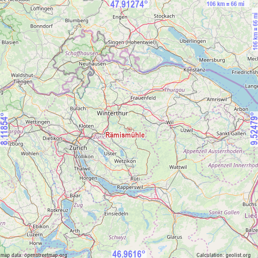
Rämismühle GPS coordinates[2]
47° 26' 21.552" North, 8° 49' 17.976" East
| Map corner | latitude | longitude |
|---|---|---|
| Upper-left | 47.91274°, | 8.11854° |
| Center: | 47.43932°, | 8.82166° |
| Lower-right: | 46.9616°, | 9.52479° |
| Map W x H: | 105.8×105.8 km | = 65.7×65.7mi |
| max Lat: | 47.76737° ⇑19.2% North |
| Rämismühle: | 47.43932° |
| min Lat: | ⇓80.8% South 45.83203° |
| min Long | Rämismühle | max Long |
| 5.97153° | 8.82166° | 10.44624° |
| W 82%⇐ | ⇒18% E |
Elevation
Elevation of Rämismühle is 534 m = 1752 ft, and this is 24.2 m = 79 ft below average elevation for this country.
| Max E: |
1845 m = 6053 ft | 37.3% |
| Avg. | 558.2 m = 1831 ft | |
| Rämismühle | 534 m = 1752 ft | |
Min E: |
197 m = 646 ft | 62.7% |
See also: Switzerland elevation on elevation.city.
Geographical zone
Rämismühle is located in North temperate zone (between Tropic of Cancer and the Arctic Circle). Distance of this North polar circle is 2126.4 km =1321.3 mi to North.| Distance of | km | miles | from Rämismühle |
|---|---|---|---|
| North Pole | 4732.3 | 2940.5 | to North |
| Arctic Circle | 2126.4 | 1321.3 | to North |
| Tropic Cancer | 2668.8 | 1658.3 | to South |
| Equator | 5274.8 | 3277.6 | to South |


Nearby cities:
15 places around Rämismühle: (largest is in red/bold)
• Kollbrunn
3.6 km =2.2 mi,  305°
305°
• Kollbrunn / Kollbrunn (Dorfkern)
4.1 km =2.5 mi,  299°
299°
• Rikon / Rikon (Dorfkern)
1.9 km =1.2 mi,  292°
292°
• Russikon
5.9 km =3.7 mi,  216°
216°
• Saland
5.9 km =3.7 mi,  156°
156°
• Schottikon
6.7 km =4.2 mi,  355°
355°
• Seen (Kreis 3)
5.7 km =3.5 mi,  316°
316°
• Seen (Kreis 3) / Büelwiesen
6.6 km =4.1 mi, 319°
• Seen (Kreis 3) / Ganzenbühl
6.4 km =4 mi, 316°
• Seen (Kreis 3) / Iberg
4.4 km =2.7 mi, 310°
• Seen (Kreis 3) / Oberseen
6 km =3.7 mi, 322°
• Seen (Kreis 3) / Sennhof
5.8 km =3.6 mi, 303°
• Turbenthal
1.9 km =1.2 mi,  100°
100°
• Weisslingen
4.2 km =2.6 mi,  256°
256°
• Wila
2.8 km =1.7 mi,  141°
141°
Sources, notices
• [Note1] Compared only with cities in Switzerland existing in our database
• [Src1] Map data: © OpenStreetMap contributors (CC-BY-SA)
• [Src2] Other city data from geonames.org with taken over terms of usage.
• [Src3] Geographical zone / Annual Mean Temperature by Robert A. Rohde @ Wikipedia
