Interlaken geodata
Interlaken (Bern) is a seat of a second-order administrative division; located in Switzerland in Europe/Zurich (GMT+2) time zone. With population of 5,067 people, there are 336 cities with bigger population in this country. Compared to other cities in Switzerland, 79.1% of cities are located further ↑North; 63.5% of cities are located further →East and 69.4% of cities have lower elevation than Interlaken. Note1


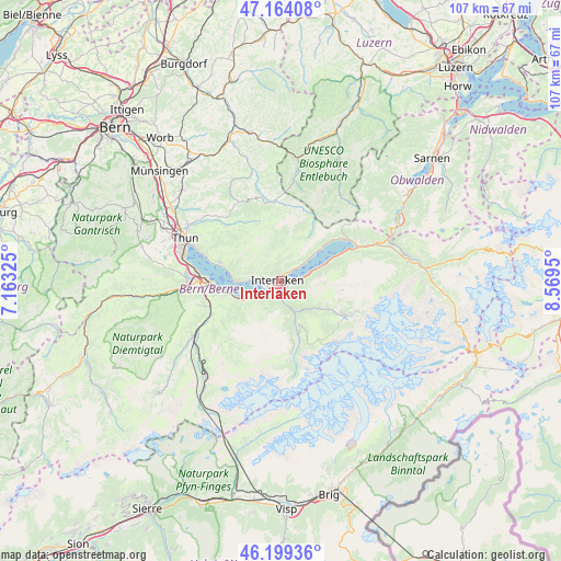
Interlaken GPS coordinates[2]
46° 41' 1.932" North, 7° 51' 58.968" East
| Map corner | latitude | longitude |
|---|---|---|
| Upper-left | 47.16408°, | 7.16325° |
| Center: | 46.68387°, | 7.86638° |
| Lower-right: | 46.19936°, | 8.5695° |
| Map W x H: | 107.3×107.3 km | = 66.7×66.7mi |
| max Lat: | 47.76737° ⇑79.1% North |
| Interlaken: | 46.68387° |
| min Lat: | ⇓20.9% South 45.83203° |
| min Long | Interlaken | max Long |
| 5.97153° | 7.86638° | 10.44624° |
| W 36.5%⇐ | ⇒63.5% E |
Elevation
Elevation of Interlaken is 570 m = 1870 ft, and this is 11.8 m = 39 ft above average elevation for this country.
| Max E: |
1845 m = 6053 ft | 30.6% |
| Interlaken | 570 m 1870 ft | |
| Avg. | 558.2 m = 1831 ft | |
Min E: |
197 m = 646 ft | 69.4% |
See also: Switzerland elevation on elevation.city.
Geographical zone
Interlaken is located in North temperate zone (between Tropic of Cancer and the Arctic Circle). Distance of this North polar circle is 2210.4 km =1373.5 mi to North.| Distance of | km | miles | from Interlaken |
|---|---|---|---|
| North Pole | 4816.3 | 2992.7 | to North |
| Arctic Circle | 2210.4 | 1373.5 | to North |
| Tropic Cancer | 2584.8 | 1606.1 | to South |
| Equator | 5190.8 | 3225.4 | to South |


Nearby cities:
15 places around Interlaken: (largest is in red/bold)
• Aeschi b. Spiez
13.3 km =8.3 mi,  257°
257°
• Beatenberg
5.7 km =3.5 mi,  286°
286°
• Bönigen
2.1 km =1.3 mi,  79°
79°
• Därligen
5.1 km =3.2 mi,  241°
241°
• Gsteig
2.1 km =1.3 mi,  166°
166°
• Habkern
4.7 km =2.9 mi,  356°
356°
• Krattigen
10.9 km =6.8 mi, 256°
• Lauterbrunnen
10.6 km =6.6 mi,  161°
161°
• Leissigen
7.7 km =4.8 mi, 244°
• Matten
0.6 km =0.4 mi, 162°
• Ringgenberg
2.9 km =1.8 mi,  48°
48°
• Sigriswil
12.2 km =7.6 mi, 287°
• Spiez
13.4 km =8.3 mi,  270°
270°
• Unterseen
1.5 km =0.9 mi,  276°
276°
• Wilderswil
2.3 km =1.4 mi,  188°
188°
Sources, notices
• [Note1] Compared only with cities in Switzerland existing in our database
• [Src1] Map data: © OpenStreetMap contributors (CC-BY-SA)
• [Src2] Other city data from geonames.org with taken over terms of usage.
• [Src3] Geographical zone / Annual Mean Temperature by Robert A. Rohde @ Wikipedia
