Delémont geodata
Delémont (Jura) is a seat of a first-order administrative division; located in Switzerland in Europe/Zurich (GMT+2) time zone. With population of 11,315 people, there are 121 cities with bigger population in this country. Compared to other cities in Switzerland, 66.9% of cities are located further ↓South; 78.9% of cities are located further →East and 74.4% of cities have higher elevation than Delémont. Note1


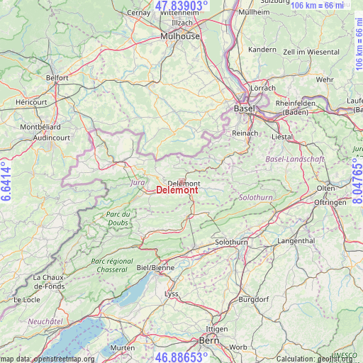
Delémont GPS coordinates[2]
47° 21' 53.748" North, 7° 20' 40.308" East
| Map corner | latitude | longitude |
|---|---|---|
| Upper-left | 47.83903°, | 6.6414° |
| Center: | 47.36493°, | 7.34453° |
| Lower-right: | 46.88653°, | 8.04765° |
| Map W x H: | 105.9×105.9 km | = 65.8×65.8mi |
| max Lat: | 47.76737° ⇑33.1% North |
| Delémont: | 47.36493° |
| min Lat: | ⇓66.9% South 45.83203° |
| min Long | Delémont | max Long |
| 5.97153° | 7.34453° | 10.44624° |
| W 21.1%⇐ | ⇒78.9% E |
Elevation
Elevation of Delémont is 432 m = 1417 ft, and this is 126.2 m = 414 ft below average elevation for this country.
| Max E: |
1845 m = 6053 ft | 74.4% |
| Avg. | 558.2 m = 1831 ft | |
| Delémont | 432 m = 1417 ft | |
Min E: |
197 m = 646 ft | 25.6% |
See also: Switzerland elevation on elevation.city.
Geographical zone
Delémont is located in North temperate zone (between Tropic of Cancer and the Arctic Circle). Distance of this North polar circle is 2134.7 km =1326.4 mi to North.| Distance of | km | miles | from Delémont |
|---|---|---|---|
| North Pole | 4740.6 | 2945.7 | to North |
| Arctic Circle | 2134.7 | 1326.4 | to North |
| Tropic Cancer | 2660.6 | 1653.2 | to South |
| Equator | 5266.5 | 3272.5 | to South |


Nearby cities:
15 places around Delémont: (largest is in red/bold)
• Bassecourt
8.2 km =5.1 mi,  248°
248°
• Bärschwil
9.8 km =6.1 mi,  78°
78°
• Courfaivre
5.8 km =3.6 mi,  234°
234°
• Courrendlin
3.6 km =2.2 mi,  144°
144°
• Courroux
2.2 km =1.4 mi,  102°
102°
• Courtételle
3.3 km =2.1 mi,  216°
216°
• Crémines
11.6 km =7.2 mi, 141°
• Glovelier
11 km =6.8 mi, 252°
• Kleinlützel
8.6 km =5.3 mi,  38°
38°
• Liesberg
7.6 km =4.7 mi,  55°
55°
• Mervelier
11.9 km =7.4 mi, 101°
• Moutier
9.8 km =6.1 mi,  168°
168°
• Perrefitte
9.9 km =6.2 mi,  181°
181°
• Röschenz
12.1 km =7.5 mi, 57°
• Vicques
5.4 km =3.4 mi,  107°
107°
Sources, notices
• [Note1] Compared only with cities in Switzerland existing in our database
• [Src1] Map data: © OpenStreetMap contributors (CC-BY-SA)
• [Src2] Other city data from geonames.org with taken over terms of usage.
• [Src3] Geographical zone / Annual Mean Temperature by Robert A. Rohde @ Wikipedia
