Courroux geodata
Courroux (Jura) is a populated place; located in Switzerland in Europe/Zurich (GMT+2) time zone. With population of 3,085 people, there are 574 cities with bigger population in this country. Compared to other cities in Switzerland, 66% of cities are located further ↓South; 78.3% of cities are located further →East and 82.2% of cities have higher elevation than Courroux. Note1


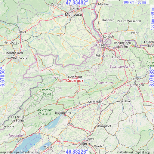
Courroux GPS coordinates[2]
47° 21' 38.484" North, 7° 22' 25.356" East
| Map corner | latitude | longitude |
|---|---|---|
| Upper-left | 47.83482°, | 6.67058° |
| Center: | 47.36069°, | 7.37371° |
| Lower-right: | 46.88226°, | 8.07683° |
| Map W x H: | 105.9×105.9 km | = 65.8×65.8mi |
| max Lat: | 47.76737° ⇑34% North |
| Courroux: | 47.36069° |
| min Lat: | ⇓66% South 45.83203° |
| min Long | Courroux | max Long |
| 5.97153° | 7.37371° | 10.44624° |
| W 21.7%⇐ | ⇒78.3% E |
Elevation
Elevation of Courroux is 417 m = 1368 ft, and this is 141.2 m = 463 ft below average elevation for this country.
| Max E: |
1845 m = 6053 ft | 82.2% |
| Avg. | 558.2 m = 1831 ft | |
| Courroux | 417 m = 1368 ft | |
Min E: |
197 m = 646 ft | 17.8% |
See also: Switzerland elevation on elevation.city.
Geographical zone
Courroux is located in North temperate zone (between Tropic of Cancer and the Arctic Circle). Distance of this North polar circle is 2135.2 km =1326.8 mi to North.| Distance of | km | miles | from Courroux |
|---|---|---|---|
| North Pole | 4741 | 2945.9 | to North |
| Arctic Circle | 2135.2 | 1326.8 | to North |
| Tropic Cancer | 2660.1 | 1652.9 | to South |
| Equator | 5266 | 3272.1 | to South |


Nearby cities:
15 places around Courroux: (largest is in red/bold)
• Bassecourt
10.1 km =6.3 mi,  255°
255°
• Bärschwil
7.8 km =4.8 mi,  72°
72°
• Courfaivre
7.5 km =4.7 mi,  247°
247°
• Courrendlin
2.5 km =1.6 mi,  182°
182°
• Courtételle
4.7 km =2.9 mi,  242°
242°
• Crémines
10 km =6.2 mi,  149°
149°
• Delémont
2.2 km =1.4 mi,  282°
282°
• Kleinlützel
7.8 km =4.8 mi,  23°
23°
• Liesberg
6.3 km =3.9 mi,  40°
40°
• Mervelier
9.7 km =6 mi,  101°
101°
• Moutier
9.2 km =5.7 mi, 181°
• Perrefitte
9.8 km =6.1 mi,  194°
194°
• Röschenz
10.6 km =6.6 mi,  48°
48°
• Vicques
3.2 km =2 mi,  111°
111°
• Wahlen
11.6 km =7.2 mi, 66°
Sources, notices
• [Note1] Compared only with cities in Switzerland existing in our database
• [Src1] Map data: © OpenStreetMap contributors (CC-BY-SA)
• [Src2] Other city data from geonames.org with taken over terms of usage.
• [Src3] Geographical zone / Annual Mean Temperature by Robert A. Rohde @ Wikipedia
