Courrendlin geodata
Courrendlin (Jura) is a populated place; located in Switzerland in Europe/Zurich (GMT+2) time zone. With population of 2,314 people, there are 734 cities with bigger population in this country. Compared to other cities in Switzerland, 63.4% of cities are located further ↓South; 78.4% of cities are located further →East and 72.4% of cities have higher elevation than Courrendlin. Note1


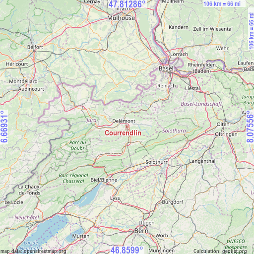
Courrendlin GPS coordinates[2]
47° 20' 18.708" North, 7° 22' 20.748" East
| Map corner | latitude | longitude |
|---|---|---|
| Upper-left | 47.81286°, | 6.66931° |
| Center: | 47.33853°, | 7.37243° |
| Lower-right: | 46.8599°, | 8.07556° |
| Map W x H: | 106×106 km | = 65.9×65.9mi |
| max Lat: | 47.76737° ⇑36.6% North |
| Courrendlin: | 47.33853° |
| min Lat: | ⇓63.4% South 45.83203° |
| min Long | Courrendlin | max Long |
| 5.97153° | 7.37243° | 10.44624° |
| W 21.6%⇐ | ⇒78.4% E |
Elevation
Elevation of Courrendlin is 436 m = 1430 ft, and this is 122.2 m = 401 ft below average elevation for this country.
| Max E: |
1845 m = 6053 ft | 72.4% |
| Avg. | 558.2 m = 1831 ft | |
| Courrendlin | 436 m = 1430 ft | |
Min E: |
197 m = 646 ft | 27.6% |
See also: Switzerland elevation on elevation.city.
Geographical zone
Courrendlin is located in North temperate zone (between Tropic of Cancer and the Arctic Circle). Distance of this North polar circle is 2137.6 km =1328.2 mi to North.| Distance of | km | miles | from Courrendlin |
|---|---|---|---|
| North Pole | 4743.5 | 2947.5 | to North |
| Arctic Circle | 2137.6 | 1328.2 | to North |
| Tropic Cancer | 2657.6 | 1651.4 | to South |
| Equator | 5263.6 | 3270.6 | to South |


Nearby cities:
15 places around Courrendlin: (largest is in red/bold)
• Bassecourt
9.7 km =6 mi,  269°
269°
• Bärschwil
9 km =5.6 mi,  57°
57°
• Courfaivre
6.8 km =4.2 mi, 266°
• Courroux
2.5 km =1.6 mi,  2°
2°
• Court
11.3 km =7 mi,  193°
193°
• Courtételle
4.1 km =2.5 mi, 273°
• Crémines
8 km =5 mi,  140°
140°
• Delémont
3.6 km =2.2 mi,  324°
324°
• Kleinlützel
10.2 km =6.3 mi,  18°
18°
• Liesberg
8.4 km =5.2 mi,  29°
29°
• Mervelier
9.6 km =6 mi,  86°
86°
• Moutier
6.7 km =4.2 mi,  181°
181°
• Perrefitte
7.4 km =4.6 mi,  198°
198°
• Röschenz
12.5 km =7.8 mi,  40°
40°
• Vicques
3.3 km =2.1 mi,  67°
67°
Sources, notices
• [Note1] Compared only with cities in Switzerland existing in our database
• [Src1] Map data: © OpenStreetMap contributors (CC-BY-SA)
• [Src2] Other city data from geonames.org with taken over terms of usage.
• [Src3] Geographical zone / Annual Mean Temperature by Robert A. Rohde @ Wikipedia
