Liesberg geodata
Liesberg (Basel-Landschaft) is a populated place; located in Switzerland in Europe/Zurich (GMT+2) time zone. With population of 1,210 people, there are 1191 cities with bigger population in this country. Compared to other cities in Switzerland, 74.5% of cities are located further ↓South; 77.3% of cities are located further →East and 62.7% of cities have lower elevation than Liesberg. Note1


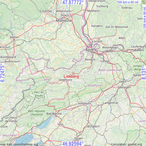
Liesberg GPS coordinates[2]
47° 24' 14.328" North, 7° 25' 40.332" East
| Map corner | latitude | longitude |
|---|---|---|
| Upper-left | 47.87772°, | 6.72475° |
| Center: | 47.40398°, | 7.42787° |
| Lower-right: | 46.92594°, | 8.131° |
| Map W x H: | 105.8×105.8 km | = 65.7×65.7mi |
| max Lat: | 47.76737° ⇑25.5% North |
| Liesberg: | 47.40398° |
| min Lat: | ⇓74.5% South 45.83203° |
| min Long | Liesberg | max Long |
| 5.97153° | 7.42787° | 10.44624° |
| W 22.7%⇐ | ⇒77.3% E |
Elevation
Elevation of Liesberg is 534 m = 1752 ft, and this is 24.2 m = 79 ft below average elevation for this country.
| Max E: |
1845 m = 6053 ft | 37.3% |
| Avg. | 558.2 m = 1831 ft | |
| Liesberg | 534 m = 1752 ft | |
Min E: |
197 m = 646 ft | 62.7% |
See also: Switzerland elevation on elevation.city.
Geographical zone
Liesberg is located in North temperate zone (between Tropic of Cancer and the Arctic Circle). Distance of this North polar circle is 2130.3 km =1323.7 mi to North.| Distance of | km | miles | from Liesberg |
|---|---|---|---|
| North Pole | 4736.2 | 2942.9 | to North |
| Arctic Circle | 2130.3 | 1323.7 | to North |
| Tropic Cancer | 2664.9 | 1655.9 | to South |
| Equator | 5270.8 | 3275.1 | to South |


Nearby cities:
15 places around Liesberg: (largest is in red/bold)
• Blauen
8.6 km =5.3 mi,  53°
53°
• Brislach
8.8 km =5.5 mi,  80°
80°
• Bärschwil
4.1 km =2.5 mi,  125°
125°
• Büsserach
8.6 km =5.3 mi,  97°
97°
• Courrendlin
8.4 km =5.2 mi,  209°
209°
• Courroux
6.3 km =3.9 mi,  220°
220°
• Delémont
7.6 km =4.7 mi,  235°
235°
• Kleinlützel
2.5 km =1.6 mi,  339°
339°
• Laufen
5.7 km =3.5 mi,  69°
69°
• Mervelier
8.6 km =5.3 mi,  141°
141°
• Rodersdorf
8.8 km =5.5 mi,  14°
14°
• Röschenz
4.5 km =2.8 mi,  60°
60°
• Vicques
6.1 km =3.8 mi,  190°
190°
• Wahlen
6.6 km =4.1 mi,  91°
91°
• Zwingen
8.6 km =5.3 mi, 63°
Sources, notices
• [Note1] Compared only with cities in Switzerland existing in our database
• [Src1] Map data: © OpenStreetMap contributors (CC-BY-SA)
• [Src2] Other city data from geonames.org with taken over terms of usage.
• [Src3] Geographical zone / Annual Mean Temperature by Robert A. Rohde @ Wikipedia
