Courgevaux geodata
Courgevaux (Fribourg) is a populated place; located in Switzerland in Europe/Zurich (GMT+2) time zone. With population of 1,057 people, there are 1295 cities with bigger population in this country. Compared to other cities in Switzerland, 69.2% of cities are located further ↑North; 84.5% of cities are located further →East and 50.9% of cities have higher elevation than Courgevaux. Note1


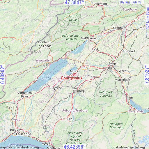
Courgevaux GPS coordinates[2]
46° 54' 23.328" North, 7° 6' 43.74" East
| Map corner | latitude | longitude |
|---|---|---|
| Upper-left | 47.3847°, | 6.40902° |
| Center: | 46.90648°, | 7.11215° |
| Lower-right: | 46.42396°, | 7.81527° |
| Map W x H: | 106.8×106.8 km | = 66.4×66.4mi |
| max Lat: | 47.76737° ⇑69.2% North |
| Courgevaux: | 46.90648° |
| min Lat: | ⇓30.8% South 45.83203° |
| min Long | Courgevaux | max Long |
| 5.97153° | 7.11215° | 10.44624° |
| W 15.5%⇐ | ⇒84.5% E |
Elevation
Elevation of Courgevaux is 476 m = 1562 ft, and this is 82.2 m = 270 ft below average elevation for this country.
| Max E: |
1845 m = 6053 ft | 50.9% |
| Avg. | 558.2 m = 1831 ft | |
| Courgevaux | 476 m = 1562 ft | |
Min E: |
197 m = 646 ft | 49.1% |
See also: Switzerland elevation on elevation.city.
Geographical zone
Courgevaux is located in North temperate zone (between Tropic of Cancer and the Arctic Circle). Distance of this North polar circle is 2185.7 km =1358.1 mi to North.| Distance of | km | miles | from Courgevaux |
|---|---|---|---|
| North Pole | 4791.6 | 2977.4 | to North |
| Arctic Circle | 2185.7 | 1358.1 | to North |
| Tropic Cancer | 2609.6 | 1621.5 | to South |
| Equator | 5215.5 | 3240.8 | to South |


Nearby cities:
15 places around Courgevaux: (largest is in red/bold)
• Avenches
6.2 km =3.9 mi,  241°
241°
• Barberêche
6.5 km =4 mi,  147°
147°
• Bas-Vully
6.2 km =3.9 mi,  0°
0°
• Bellerive
7.1 km =4.4 mi,  285°
285°
• Cordast
4.6 km =2.9 mi,  138°
138°
• Domdidier
8.7 km =5.4 mi, 239°
• Düdingen
8.8 km =5.5 mi, 136°
• Faoug
2.6 km =1.6 mi,  274°
274°
• Galmiz
5.9 km =3.7 mi,  36°
36°
• Grolley
8.7 km =5.4 mi,  201°
201°
• Jeuss
3.9 km =2.4 mi,  94°
94°
• Kleinbösingen
7.2 km =4.5 mi,  101°
101°
• Liebistorf
6.4 km =4 mi, 87°
• Murten/Morat
2.5 km =1.6 mi,  8°
8°
• Münchenwiler
1.3 km =0.8 mi,  53°
53°
Sources, notices
• [Note1] Compared only with cities in Switzerland existing in our database
• [Src1] Map data: © OpenStreetMap contributors (CC-BY-SA)
• [Src2] Other city data from geonames.org with taken over terms of usage.
• [Src3] Geographical zone / Annual Mean Temperature by Robert A. Rohde @ Wikipedia
