Kleinbösingen geodata
Kleinbösingen (Fribourg) is a seat of a third-order administrative division; located in Switzerland in Europe/Zurich (GMT+2) time zone. In our database, there are 1823 cities with bigger population. Compared to other cities in Switzerland, 70% of cities are located further ↑North; 82.1% of cities are located further →East and 54.7% of cities have lower elevation than Kleinbösingen. Note1


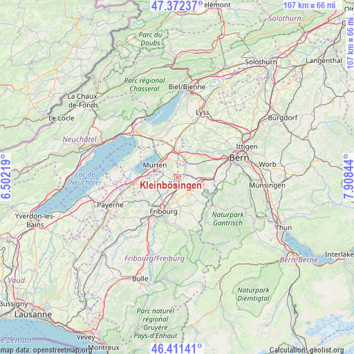
Kleinbösingen GPS coordinates[2]
46° 53' 38.544" North, 7° 12' 19.116" East
| Map corner | latitude | longitude |
|---|---|---|
| Upper-left | 47.37237°, | 6.50219° |
| Center: | 46.89404°, | 7.20531° |
| Lower-right: | 46.41141°, | 7.90844° |
| Map W x H: | 106.8×106.8 km | = 66.4×66.4mi |
| max Lat: | 47.76737° ⇑70% North |
| Kleinbösingen: | 46.89404° |
| min Lat: | ⇓30% South 45.83203° |
| min Long | Kleinbösingen | max Long |
| 5.97153° | 7.20531° | 10.44624° |
| W 17.9%⇐ | ⇒82.1% E |
Elevation
Elevation of Kleinbösingen is 494 m = 1621 ft, and this is 64.2 m = 211 ft below average elevation for this country.
| Max E: |
1845 m = 6053 ft | 45.3% |
| Avg. | 558.2 m = 1831 ft | |
| Kleinbösingen | 494 m = 1621 ft | |
Min E: |
197 m = 646 ft | 54.7% |
See also: Switzerland elevation on elevation.city.
Geographical zone
Kleinbösingen is located in North temperate zone (between Tropic of Cancer and the Arctic Circle). Distance of this North polar circle is 2187 km =1358.9 mi to North.| Distance of | km | miles | from Kleinbösingen |
|---|---|---|---|
| North Pole | 4792.9 | 2978.2 | to North |
| Arctic Circle | 2187 | 1358.9 | to North |
| Tropic Cancer | 2608.2 | 1620.7 | to South |
| Equator | 5214.1 | 3239.9 | to South |


Nearby cities:
15 places around Kleinbösingen: (largest is in red/bold)
• Barberêche
5.4 km =3.4 mi,  220°
220°
• Bösingen
1.7 km =1.1 mi,  96°
96°
• Cordast
4.5 km =2.8 mi,  243°
243°
• Courgevaux
7.2 km =4.5 mi,  281°
281°
• Düdingen
5.1 km =3.2 mi,  191°
191°
• Ferenbalm
6.1 km =3.8 mi,  4°
4°
• Galmiz
7.1 km =4.4 mi,  329°
329°
• Jeuss
3.4 km =2.1 mi,  288°
288°
• Laupen
2.8 km =1.7 mi,  70°
70°
• Liebistorf
1.8 km =1.1 mi,  337°
337°
• Murten/Morat
7.7 km =4.8 mi,  299°
299°
• Mühleberg
8 km =5 mi,  32°
32°
• Münchenwiler
6.4 km =4 mi, 289°
• Schmitten
5.3 km =3.3 mi,  139°
139°
• Ueberstorf
8.5 km =5.3 mi,  111°
111°
Sources, notices
• [Note1] Compared only with cities in Switzerland existing in our database
• [Src1] Map data: © OpenStreetMap contributors (CC-BY-SA)
• [Src2] Other city data from geonames.org with taken over terms of usage.
• [Src3] Geographical zone / Annual Mean Temperature by Robert A. Rohde @ Wikipedia
