Blécherette geodata
Blécherette (Vaud) is a section of populated place; located in Switzerland in Europe/Zurich (GMT+2) time zone. With population of 6,516 people, there are 256 cities with bigger population in this country. Compared to other cities in Switzerland, 84.1% of cities are located further ↑North; 93.7% of cities are located further →East and 73.9% of cities have lower elevation than Blécherette. Note1


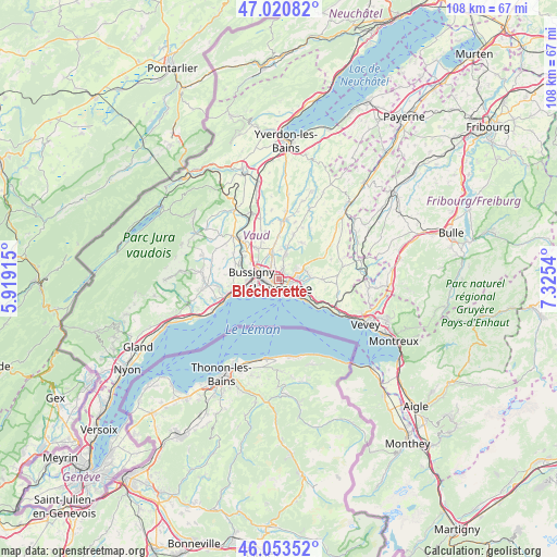
Blécherette GPS coordinates[2]
46° 32' 21.552" North, 6° 37' 20.172" East
| Map corner | latitude | longitude |
|---|---|---|
| Upper-left | 47.02082°, | 5.91915° |
| Center: | 46.53932°, | 6.62227° |
| Lower-right: | 46.05352°, | 7.3254° |
| Map W x H: | 107.6×107.6 km | = 66.9×66.9mi |
| max Lat: | 47.76737° ⇑84.1% North |
| Blécherette: | 46.53932° |
| min Lat: | ⇓15.9% South 45.83203° |
| min Long | Blécherette | max Long |
| 5.97153° | 6.62227° | 10.44624° |
| W 6.3%⇐ | ⇒93.7% E |
Elevation
Elevation of Blécherette is 606 m = 1988 ft, and this is 47.8 m = 157 ft above average elevation for this country.
| Max E: |
1845 m = 6053 ft | 26.1% |
| Blécherette | 606 m 1988 ft | |
| Avg. | 558.2 m = 1831 ft | |
Min E: |
197 m = 646 ft | 73.9% |
See also: Switzerland elevation on elevation.city.
Geographical zone
Blécherette is located in North temperate zone (between Tropic of Cancer and the Arctic Circle). Distance of this North polar circle is 2226.5 km =1383.5 mi to North.| Distance of | km | miles | from Blécherette |
|---|---|---|---|
| North Pole | 4832.4 | 3002.7 | to North |
| Arctic Circle | 2226.5 | 1383.5 | to North |
| Tropic Cancer | 2568.8 | 1596.2 | to South |
| Equator | 5174.7 | 3215.4 | to South |


Nearby cities:
15 places around Blécherette: (largest is in red/bold)
• Belmont-sur-Lausanne
4.7 km =2.9 mi,  118°
118°
• Bussigny
5.2 km =3.2 mi,  284°
284°
• Chavannes
4.1 km =2.5 mi,  255°
255°
• Cheseaux
5.4 km =3.4 mi,  346°
346°
• Crissier
3.6 km =2.2 mi, 281°
• Ecublens
4.7 km =2.9 mi, 255°
• Epalinges
3.7 km =2.3 mi,  73°
73°
• Lausanne
2.7 km =1.7 mi,  162°
162°
• Le Mont-sur-Lausanne
2.2 km =1.4 mi,  18°
18°
• Lutry
6.4 km =4 mi,  129°
129°
• Paudex
5.1 km =3.2 mi,  136°
136°
• Prilly
1.4 km =0.9 mi, 259°
• Pully
4.4 km =2.7 mi, 136°
• Renens
2.6 km =1.6 mi,  271°
271°
• Romanel-sur-Lausanne
3 km =1.9 mi,  334°
334°
Sources, notices
• [Note1] Compared only with cities in Switzerland existing in our database
• [Src1] Map data: © OpenStreetMap contributors (CC-BY-SA)
• [Src2] Other city data from geonames.org with taken over terms of usage.
• [Src3] Geographical zone / Annual Mean Temperature by Robert A. Rohde @ Wikipedia
