Romanel-sur-Lausanne geodata
Romanel-sur-Lausanne (Vaud) is a populated place; located in Switzerland in Europe/Zurich (GMT+2) time zone. With population of 3,123 people, there are 566 cities with bigger population in this country. Compared to other cities in Switzerland, 83.4% of cities are located further ↑North; 94.1% of cities are located further →East and 73.1% of cities have lower elevation than Romanel-sur-Lausanne. Note1


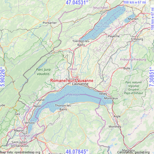
Romanel-sur-Lausanne GPS coordinates[2]
46° 33' 50.508" North, 6° 36' 19.368" East
| Map corner | latitude | longitude |
|---|---|---|
| Upper-left | 47.04531°, | 5.90226° |
| Center: | 46.56403°, | 6.60538° |
| Lower-right: | 46.07845°, | 7.30851° |
| Map W x H: | 107.5×107.5 km | = 66.8×66.8mi |
| max Lat: | 47.76737° ⇑83.4% North |
| Romanel-sur-Lausanne: | 46.56403° |
| min Lat: | ⇓16.6% South 45.83203° |
| min Long | Romanel-sur-Lau | max Long |
| 5.97153° | 6.60538° | 10.44624° |
| W 5.9%⇐ | ⇒94.1% E |
Elevation
Elevation of Romanel-sur-Lausanne is 599 m = 1965 ft, and this is 40.8 m = 134 ft above average elevation for this country.
| Max E: |
1845 m = 6053 ft | 26.9% |
| Romanel-sur-Lausanne | 599 m 1965 ft | |
| Avg. | 558.2 m = 1831 ft | |
Min E: |
197 m = 646 ft | 73.1% |
See also: Switzerland elevation on elevation.city.
Geographical zone
Romanel-sur-Lausanne is located in North temperate zone (between Tropic of Cancer and the Arctic Circle). Distance of this North polar circle is 2223.7 km =1381.7 mi to North.| Distance of | km | miles | from Romanel-sur-Lausanne |
|---|---|---|---|
| North Pole | 4829.6 | 3001 | to North |
| Arctic Circle | 2223.7 | 1381.7 | to North |
| Tropic Cancer | 2571.5 | 1597.9 | to South |
| Equator | 5177.4 | 3217.1 | to South |


Nearby cities:
15 places around Romanel-sur-Lausanne: (largest is in red/bold)
• Assens
5.6 km =3.5 mi,  13°
13°
• Belmont-sur-Lausanne
7.4 km =4.6 mi,  132°
132°
• Blécherette
3 km =1.9 mi,  154°
154°
• Bottens
7.2 km =4.5 mi,  36°
36°
• Bussigny
4 km =2.5 mi,  249°
249°
• Chavannes
4.6 km =2.9 mi,  215°
215°
• Cheseaux
2.5 km =1.6 mi,  0°
0°
• Crissier
3 km =1.9 mi,  228°
228°
• Ecublens
5.1 km =3.2 mi, 220°
• Epalinges
5.1 km =3.2 mi,  109°
109°
• Froideville
7.1 km =4.4 mi,  54°
54°
• Lausanne
5.7 km =3.5 mi,  158°
158°
• Le Mont-sur-Lausanne
2.1 km =1.3 mi, 108°
• Prilly
3 km =1.9 mi,  181°
181°
• Renens
3 km =1.9 mi,  206°
206°
Sources, notices
• [Note1] Compared only with cities in Switzerland existing in our database
• [Src1] Map data: © OpenStreetMap contributors (CC-BY-SA)
• [Src2] Other city data from geonames.org with taken over terms of usage.
• [Src3] Geographical zone / Annual Mean Temperature by Robert A. Rohde @ Wikipedia
