Rain geodata
Rain (Lucerne) is a section of populated place; located in Switzerland in Europe/Zurich (GMT+2) time zone. With population of 504 people, there are 1801 cities with bigger population in this country. Compared to other cities in Switzerland, 81.4% of cities are located further ↓South; 50.4% of cities are located further ←West and 52% of cities have higher elevation than Rain. Note1


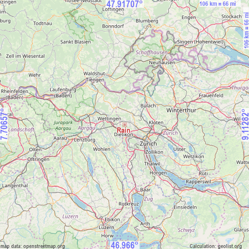
Rain GPS coordinates[2]
47° 26' 37.248" North, 8° 24' 34.92" East
| Map corner | latitude | longitude |
|---|---|---|
| Upper-left | 47.91707°, | 7.70657° |
| Center: | 47.44368°, | 8.4097° |
| Lower-right: | 46.966°, | 9.11282° |
| Map W x H: | 105.7×105.7 km | = 65.7×65.7mi |
| max Lat: | 47.76737° ⇑18.6% North |
| Rain: | 47.44368° |
| min Lat: | ⇓81.4% South 45.83203° |
| min Long | Rain | max Long |
| 5.97153° | 8.4097° | 10.44624° |
| W 50.4%⇐ | ⇒49.6% E |
Elevation
Elevation of Rain is 474 m = 1555 ft, and this is 84.2 m = 276 ft below average elevation for this country.
| Max E: |
1845 m = 6053 ft | 52% |
| Avg. | 558.2 m = 1831 ft | |
| Rain | 474 m = 1555 ft | |
Min E: |
197 m = 646 ft | 48% |
See also: Switzerland elevation on elevation.city.
Geographical zone
Rain is located in North temperate zone (between Tropic of Cancer and the Arctic Circle). Distance of this North polar circle is 2125.9 km =1321 mi to North.| Distance of | km | miles | from Rain |
|---|---|---|---|
| North Pole | 4731.8 | 2940.2 | to North |
| Arctic Circle | 2125.9 | 1321 | to North |
| Tropic Cancer | 2669.3 | 1658.6 | to South |
| Equator | 5275.2 | 3277.9 | to South |


Nearby cities:
15 places around Rain: (largest is in red/bold)
• Boppelsen
2.9 km =1.8 mi,  354°
354°
• Buchs / Buchs (Nord)
2.7 km =1.7 mi,  45°
45°
• Buchs / Ringstrasse
2.6 km =1.6 mi,  61°
61°
• Buchs / Zürcherstrasse
2.8 km =1.7 mi, 57°
• Dällikon / Dällikon (Dorf)
2.2 km =1.4 mi,  101°
101°
• Dällikon / Sytenacher
2.7 km =1.7 mi, 102°
• Dänikon
0.4 km =0.2 mi,  324°
324°
• Dänikon / Bifang
0.4 km =0.2 mi, 345°
• Geroldswil
2.4 km =1.5 mi,  177°
177°
• Geroldswil / Bergacker
2 km =1.2 mi, 181°
• Geroldswil / Haslern
2.6 km =1.6 mi,  169°
169°
• Geroldswil / Huebwiesen
2.4 km =1.5 mi, 180°
• Oetwil / Oetwil an der Limmat
2 km =1.2 mi,  213°
213°
• Otelfingen
2.3 km =1.4 mi, 323°
• Weiningen
3.3 km =2.1 mi,  142°
142°
Sources, notices
• [Note1] Compared only with cities in Switzerland existing in our database
• [Src1] Map data: © OpenStreetMap contributors (CC-BY-SA)
• [Src2] Other city data from geonames.org with taken over terms of usage.
• [Src3] Geographical zone / Annual Mean Temperature by Robert A. Rohde @ Wikipedia
