Horgen / Allmend geodata
Horgen / Allmend (Zurich) is a section of populated place; located in Switzerland in Europe/Zurich (GMT+2) time zone. With population of 3,809 people, there are 467 cities with bigger population in this country. Compared to other cities in Switzerland, 51.5% of cities are located further ↓South; 66.9% of cities are located further ←West and 59.4% of cities have lower elevation than Horgen / Allmend. Note1


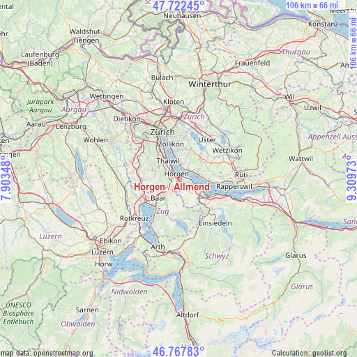
Horgen / Allmend GPS coordinates[2]
47° 14' 50.244" North, 8° 36' 23.76" East
| Map corner | latitude | longitude |
|---|---|---|
| Upper-left | 47.72245°, | 7.90348° |
| Center: | 47.24729°, | 8.6066° |
| Lower-right: | 46.76783°, | 9.30973° |
| Map W x H: | 106.1×106.1 km | = 65.9×65.9mi |
| max Lat: | 47.76737° ⇑48.5% North |
| Horgen / Allmend: | 47.24729° |
| min Lat: | ⇓51.5% South 45.83203° |
| min Long | Horgen / Allmen | max Long |
| 5.97153° | 8.6066° | 10.44624° |
| W 66.9%⇐ | ⇒33.1% E |
Elevation
Elevation of Horgen / Allmend is 515 m = 1690 ft, and this is 43.2 m = 142 ft below average elevation for this country.
| Max E: |
1845 m = 6053 ft | 40.6% |
| Avg. | 558.2 m = 1831 ft | |
| Horgen / Allmend | 515 m = 1690 ft | |
Min E: |
197 m = 646 ft | 59.4% |
See also: Switzerland elevation on elevation.city.
Geographical zone
Horgen / Allmend is located in North temperate zone (between Tropic of Cancer and the Arctic Circle). Distance of this North polar circle is 2147.8 km =1334.6 mi to North.| Distance of | km | miles | from Horgen / Allmend |
|---|---|---|---|
| North Pole | 4753.7 | 2953.8 | to North |
| Arctic Circle | 2147.8 | 1334.6 | to North |
| Tropic Cancer | 2647.5 | 1645.1 | to South |
| Equator | 5253.4 | 3264.3 | to South |


Nearby cities:
15 places around Horgen / Allmend: (largest is in red/bold)
• Au
2.9 km =1.8 mi,  102°
102°
• Au / Mittel-Dorf
3 km =1.9 mi, 99°
• Au / Ober-Ort/Gwad
3.9 km =2.4 mi, 102°
• Au / Unter-Dorf
2 km =1.2 mi,  89°
89°
• Feldmeilen
3.7 km =2.3 mi,  17°
17°
• Horgen
1.5 km =0.9 mi,  334°
334°
• Horgen / Horgen (Dorfkern)
1 km =0.6 mi,  338°
338°
• Horgen / Käpfnach
0.9 km =0.6 mi,  32°
32°
• Horgen / Oberdorf
1.8 km =1.1 mi,  314°
314°
• Horgen / Scheller-Stockerstrasse
2.5 km =1.6 mi, 325°
• Meilen
4.1 km =2.5 mi,  47°
47°
• Oberrieden
3.7 km =2.3 mi,  324°
324°
• Oberrieden / Mitte
3.4 km =2.1 mi, 324°
• Oberrieden / See
3.5 km =2.2 mi, 328°
• Wädenswil / Hangenmoos
3.8 km =2.4 mi,  113°
113°
Sources, notices
• [Note1] Compared only with cities in Switzerland existing in our database
• [Src1] Map data: © OpenStreetMap contributors (CC-BY-SA)
• [Src2] Other city data from geonames.org with taken over terms of usage.
• [Src3] Geographical zone / Annual Mean Temperature by Robert A. Rohde @ Wikipedia
