Oberrieden / Mitte geodata
Oberrieden / Mitte (Zurich) is a section of populated place; located in Switzerland in Europe/Zurich (GMT+2) time zone. With population of 1,807 people, there are 906 cities with bigger population in this country. Compared to other cities in Switzerland, 54.7% of cities are located further ↓South; 64% of cities are located further ←West and 63.8% of cities have higher elevation than Oberrieden / Mitte. Note1


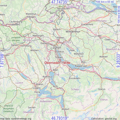
Oberrieden / Mitte GPS coordinates[2]
47° 16' 20.712" North, 8° 34' 48.756" East
| Map corner | latitude | longitude |
|---|---|---|
| Upper-left | 47.74735°, | 7.87708° |
| Center: | 47.27242°, | 8.58021° |
| Lower-right: | 46.79319°, | 9.28333° |
| Map W x H: | 106.1×106.1 km | = 65.9×65.9mi |
| max Lat: | 47.76737° ⇑45.3% North |
| Oberrieden / Mitte: | 47.27242° |
| min Lat: | ⇓54.7% South 45.83203° |
| min Long | Oberrieden / Mi | max Long |
| 5.97153° | 8.58021° | 10.44624° |
| W 64%⇐ | ⇒36% E |
Elevation
Elevation of Oberrieden / Mitte is 448 m = 1470 ft, and this is 110.2 m = 362 ft below average elevation for this country.
| Max E: |
1845 m = 6053 ft | 63.8% |
| Avg. | 558.2 m = 1831 ft | |
| Oberrieden / Mitte | 448 m = 1470 ft | |
Min E: |
197 m = 646 ft | 36.2% |
See also: Switzerland elevation on elevation.city.
Geographical zone
Oberrieden / Mitte is located in North temperate zone (between Tropic of Cancer and the Arctic Circle). Distance of this North polar circle is 2145 km =1332.8 mi to North.| Distance of | km | miles | from Oberrieden / Mitte |
|---|---|---|---|
| North Pole | 4750.9 | 2952.1 | to North |
| Arctic Circle | 2145 | 1332.8 | to North |
| Tropic Cancer | 2650.3 | 1646.8 | to South |
| Equator | 5256.2 | 3266.1 | to South |


Nearby cities:
15 places around Oberrieden / Mitte: (largest is in red/bold)
• Feldmeilen
3.2 km =2 mi,  77°
77°
• Gattikon
2.8 km =1.7 mi,  298°
298°
• Horgen
1.9 km =1.2 mi,  136°
136°
• Horgen / Horgen (Dorfkern)
2.4 km =1.5 mi, 138°
• Horgen / Käpfnach
3.2 km =2 mi,  128°
128°
• Horgen / Oberdorf
1.7 km =1.1 mi,  154°
154°
• Horgen / Scheller-Stockerstrasse
0.9 km =0.6 mi, 142°
• Oberrieden
0.3 km =0.2 mi,  328°
328°
• Oberrieden / Berg
0.7 km =0.4 mi,  306°
306°
• Oberrieden / See
0.3 km =0.2 mi,  33°
33°
• Thalwil
2.5 km =1.6 mi, 329°
• Thalwil / Berg
2.8 km =1.7 mi,  319°
319°
• Thalwil / Dorfkern
2.3 km =1.4 mi, 332°
• Thalwil / See
2.5 km =1.6 mi,  341°
341°
• Thalwil / Süd
1.6 km =1 mi, 329°
Sources, notices
• [Note1] Compared only with cities in Switzerland existing in our database
• [Src1] Map data: © OpenStreetMap contributors (CC-BY-SA)
• [Src2] Other city data from geonames.org with taken over terms of usage.
• [Src3] Geographical zone / Annual Mean Temperature by Robert A. Rohde @ Wikipedia
