Thalwil / See geodata
Thalwil / See (Zurich) is a section of populated place; located in Switzerland in Europe/Zurich (GMT+2) time zone. With population of 1,893 people, there are 874 cities with bigger population in this country. Compared to other cities in Switzerland, 57.3% of cities are located further ↓South; 63.1% of cities are located further ←West and 79.2% of cities have higher elevation than Thalwil / See. Note1


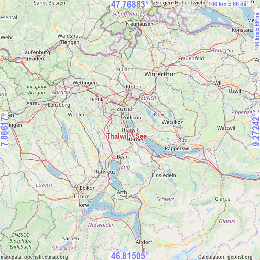
Thalwil / See GPS coordinates[2]
47° 17' 38.724" North, 8° 34' 9.444" East
| Map corner | latitude | longitude |
|---|---|---|
| Upper-left | 47.76883°, | 7.86617° |
| Center: | 47.29409°, | 8.56929° |
| Lower-right: | 46.81505°, | 9.27242° |
| Map W x H: | 106.1×10⁶ km | = 65.9×65.9mi |
| max Lat: | 47.76737° ⇑42.7% North |
| Thalwil / See: | 47.29409° |
| min Lat: | ⇓57.3% South 45.83203° |
| min Long | Thalwil / See | max Long |
| 5.97153° | 8.56929° | 10.44624° |
| W 63.1%⇐ | ⇒36.9% E |
Elevation
Elevation of Thalwil / See is 423 m = 1388 ft, and this is 135.2 m = 444 ft below average elevation for this country.
| Max E: |
1845 m = 6053 ft | 79.2% |
| Avg. | 558.2 m = 1831 ft | |
| Thalwil / See | 423 m = 1388 ft | |
Min E: |
197 m = 646 ft | 20.8% |
See also: Switzerland elevation on elevation.city.
Geographical zone
Thalwil / See is located in North temperate zone (between Tropic of Cancer and the Arctic Circle). Distance of this North polar circle is 2142.6 km =1331.3 mi to North.| Distance of | km | miles | from Thalwil / See |
|---|---|---|---|
| North Pole | 4748.5 | 2950.6 | to North |
| Arctic Circle | 2142.6 | 1331.3 | to North |
| Tropic Cancer | 2652.7 | 1648.3 | to South |
| Equator | 5258.6 | 3267.5 | to South |


Nearby cities:
15 places around Thalwil / See: (largest is in red/bold)
• Erlenbach
2.3 km =1.4 mi,  65°
65°
• Erlenbach / links des Dorfbachs unterhalb Bahnlinie
2.1 km =1.3 mi, 69°
• Erlenbach / rechts des Dorfbachs unterhalb Bahnlinie
2 km =1.2 mi,  51°
51°
• Gattikon
1.9 km =1.2 mi,  235°
235°
• Langnau am Albis
2.2 km =1.4 mi,  254°
254°
• Oberrieden
2.3 km =1.4 mi,  162°
162°
• Oberrieden / Berg
2 km =1.2 mi,  172°
172°
• Oberrieden / See
2.4 km =1.5 mi, 155°
• Rüschlikon
2 km =1.2 mi,  316°
316°
• Rüschlikon / Alte Landstrasse
1.6 km =1 mi,  313°
313°
• Thalwil
0.5 km =0.3 mi, 239°
• Thalwil / Berg
1 km =0.6 mi,  255°
255°
• Thalwil / Dorfkern
0.5 km =0.3 mi,  209°
209°
• Thalwil / Nord
1 km =0.6 mi,  291°
291°
• Thalwil / Süd
1 km =0.6 mi,  178°
178°
Sources, notices
• [Note1] Compared only with cities in Switzerland existing in our database
• [Src1] Map data: © OpenStreetMap contributors (CC-BY-SA)
• [Src2] Other city data from geonames.org with taken over terms of usage.
• [Src3] Geographical zone / Annual Mean Temperature by Robert A. Rohde @ Wikipedia
