Schlieren / Kamp geodata
Schlieren / Kamp (Zurich) is a section of populated place; located in Switzerland in Europe/Zurich (GMT+2) time zone. With population of 1,129 people, there are 1243 cities with bigger population in this country. Compared to other cities in Switzerland, 72% of cities are located further ↓South; 52.8% of cities are located further ←West and 82.8% of cities have higher elevation than Schlieren / Kamp. Note1


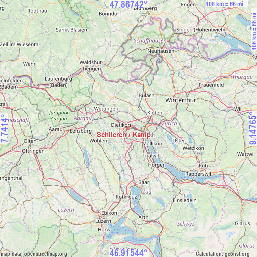
Schlieren / Kamp GPS coordinates[2]
47° 23' 36.888" North, 8° 26' 40.308" East
| Map corner | latitude | longitude |
|---|---|---|
| Upper-left | 47.86742°, | 7.7414° |
| Center: | 47.39358°, | 8.44453° |
| Lower-right: | 46.91544°, | 9.14765° |
| Map W x H: | 105.9×105.8 km | = 65.8×65.7mi |
| max Lat: | 47.76737° ⇑28% North |
| Schlieren / Kamp: | 47.39358° |
| min Lat: | ⇓72% South 45.83203° |
| min Long | Schlieren / Kam | max Long |
| 5.97153° | 8.44453° | 10.44624° |
| W 52.8%⇐ | ⇒47.2% E |
Elevation
Elevation of Schlieren / Kamp is 416 m = 1365 ft, and this is 142.2 m = 467 ft below average elevation for this country.
| Max E: |
1845 m = 6053 ft | 82.8% |
| Avg. | 558.2 m = 1831 ft | |
| Schlieren / Kamp | 416 m = 1365 ft | |
Min E: |
197 m = 646 ft | 17.2% |
See also: Switzerland elevation on elevation.city.
Geographical zone
Schlieren / Kamp is located in North temperate zone (between Tropic of Cancer and the Arctic Circle). Distance of this North polar circle is 2131.5 km =1324.5 mi to North.| Distance of | km | miles | from Schlieren / Kamp |
|---|---|---|---|
| North Pole | 4737.4 | 2943.7 | to North |
| Arctic Circle | 2131.5 | 1324.5 | to North |
| Tropic Cancer | 2663.8 | 1655.2 | to South |
| Equator | 5269.7 | 3274.4 | to South |


Nearby cities:
15 places around Schlieren / Kamp: (largest is in red/bold)
• Dietikon / Schönenwerd
1.5 km =0.9 mi,  285°
285°
• Schlieren
0.4 km =0.2 mi,  34°
34°
• Schlieren / Boden
1 km =0.6 mi,  67°
67°
• Schlieren / Engstingerquartier
1.1 km =0.7 mi,  356°
356°
• Schlieren / Freiestrasse
0.3 km =0.2 mi,  324°
324°
• Schlieren / Halde
1.3 km =0.8 mi,  78°
78°
• Schlieren / Industrie Ost
1.5 km =0.9 mi,  57°
57°
• Schlieren / Pflugstrasse
0.7 km =0.4 mi,  295°
295°
• Schlieren / Spital
1.1 km =0.7 mi,  277°
277°
• Schlieren / Zentrum
0.5 km =0.3 mi, 27°
• Urdorf
1.7 km =1.1 mi,  236°
236°
• Urdorf / Bodenfeld
1.7 km =1.1 mi,  253°
253°
• Urdorf / Heidenkeller
1.6 km =1 mi,  232°
232°
• Urdorf / Moos
1.3 km =0.8 mi, 250°
• Urdorf / Ob der Bahn
1.1 km =0.7 mi, 229°
Sources, notices
• [Note1] Compared only with cities in Switzerland existing in our database
• [Src1] Map data: © OpenStreetMap contributors (CC-BY-SA)
• [Src2] Other city data from geonames.org with taken over terms of usage.
• [Src3] Geographical zone / Annual Mean Temperature by Robert A. Rohde @ Wikipedia
