Urdorf / Heidenkeller geodata
Urdorf / Heidenkeller (Zurich) is a section of populated place; located in Switzerland in Europe/Zurich (GMT+2) time zone. With population of 743 people, there are 1547 cities with bigger population in this country. Compared to other cities in Switzerland, 70.1% of cities are located further ↓South; 51.5% of cities are located further ←West and 73.6% of cities have higher elevation than Urdorf / Heidenkeller. Note1
Current local time in Urdorf / Heidenkeller:
08:58 AM, SaturdayDifference from your time zone: hours


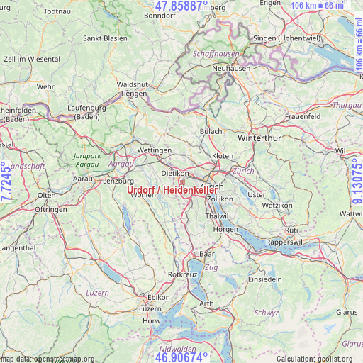
Urdorf / Heidenkeller GPS coordinates[2]
47° 23' 5.82" North, 8° 25' 39.468" East
| Map corner | latitude | longitude |
|---|---|---|
| Upper-left | 47.85887°, | 7.7245° |
| Center: | 47.38495°, | 8.42763° |
| Lower-right: | 46.90674°, | 9.13075° |
| Map W x H: | 105.9×105.9 km | = 65.8×65.8mi |
| max Lat: | 47.76737° ⇑29.9% North |
| Urdorf / Heidenkeller: | 47.38495° |
| min Lat: | ⇓70.1% South 45.83203° |
| min Long | Urdorf / Heiden | max Long |
| 5.97153° | 8.42763° | 10.44624° |
| W 51.5%⇐ | ⇒48.5% E |
Elevation
Elevation of Urdorf / Heidenkeller is 434 m = 1424 ft, and this is 124.2 m = 407 ft below average elevation for this country.
| Max E: |
1845 m = 6053 ft | 73.6% |
| Avg. | 558.2 m = 1831 ft | |
| Urdorf / Heidenkeller | 434 m = 1424 ft | |
Min E: |
197 m = 646 ft | 26.4% |
See also: Switzerland elevation on elevation.city.
Geographical zone
Urdorf / Heidenkeller is located in North temperate zone (between Tropic of Cancer and the Arctic Circle). Distance of this North polar circle is 2132.5 km =1325.1 mi to North.| Distance of | km | miles | from Urdorf / Heidenkeller |
|---|---|---|---|
| North Pole | 4738.3 | 2944.2 | to North |
| Arctic Circle | 2132.5 | 1325.1 | to North |
| Tropic Cancer | 2662.8 | 1654.6 | to South |
| Equator | 5268.7 | 3273.8 | to South |


Nearby cities:
15 places around Urdorf / Heidenkeller: (largest is in red/bold)
• Dietikon / Hofacker
1.6 km =1 mi,  327°
327°
• Dietikon / Schönenwerd
1.4 km =0.9 mi,  354°
354°
• Schlieren / Freiestrasse
1.6 km =1 mi,  41°
41°
• Schlieren / Kamp
1.6 km =1 mi,  52°
52°
• Schlieren / Pflugstrasse
1.4 km =0.9 mi,  26°
26°
• Schlieren / Spital
1.1 km =0.7 mi,  10°
10°
• Urdorf
0.1 km =0.1 mi,  275°
275°
• Urdorf / Baumgarten
0.8 km =0.5 mi,  217°
217°
• Urdorf / Bodenfeld
0.6 km =0.4 mi,  321°
321°
• Urdorf / Fadmatt
0.3 km =0.2 mi,  168°
168°
• Urdorf / Moos
0.5 km =0.3 mi, 9°
• Urdorf / Nieder-Urdorf
1.1 km =0.7 mi, 326°
• Urdorf / Ob der Bahn
0.5 km =0.3 mi,  60°
60°
• Urdorf / Oberurdorf
0.6 km =0.4 mi,  213°
213°
• Urdorf / Zentrum
0.3 km =0.2 mi,  289°
289°
Sources, notices
• [Note1] Compared only with cities in Switzerland existing in our database
• [Src1] Map data: © OpenStreetMap contributors (CC-BY-SA)
• [Src2] Other city data from geonames.org with taken over terms of usage.
• [Src3] Geographical zone / Annual Mean Temperature by Robert A. Rohde @ Wikipedia
