Zürich (Kreis 12) / Saatlen geodata
Zürich (Kreis 12) / Saatlen (Zurich) is a section of populated place; located in Switzerland in Europe/Zurich (GMT+2) time zone. With population of 5,209 people, there are 328 cities with bigger population in this country. Compared to other cities in Switzerland, 76% of cities are located further ↓South; 62.7% of cities are located further ←West and 75.9% of cities have higher elevation than Zürich (Kreis 12) / Saatlen. Note1
Current local time in Zürich (Kreis 12) / Saatlen:
08:58 AM, SaturdayDifference from your time zone: hours


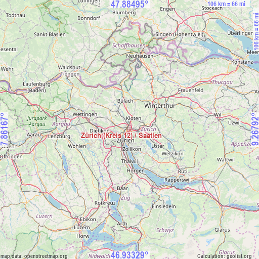
Zürich (Kreis 12) / Saatlen GPS coordinates[2]
47° 24' 40.572" North, 8° 33' 53.28" East
| Map corner | latitude | longitude |
|---|---|---|
| Upper-left | 47.88495°, | 7.86167° |
| Center: | 47.41127°, | 8.5648° |
| Lower-right: | 46.93329°, | 9.26792° |
| Map W x H: | 105.8×105.8 km | = 65.7×65.7mi |
| max Lat: | 47.76737° ⇑24% North |
| Zürich (Kreis 12) / Saatlen: | 47.41127° |
| min Lat: | ⇓76% South 45.83203° |
| min Long | Zürich (Kreis | max Long |
| 5.97153° | 8.5648° | 10.44624° |
| W 62.7%⇐ | ⇒37.3% E |
Elevation
Elevation of Zürich (Kreis 12) / Saatlen is 430 m = 1411 ft, and this is 128.2 m = 421 ft below average elevation for this country.
| Max E: |
1845 m = 6053 ft | 75.9% |
| Avg. | 558.2 m = 1831 ft | |
| Zürich (Kreis 12) / Saatlen | 430 m = 1411 ft | |
Min E: |
197 m = 646 ft | 24.1% |
See also: Switzerland elevation on elevation.city.
Geographical zone
Zürich (Kreis 12) / Saatlen is located in North temperate zone (between Tropic of Cancer and the Arctic Circle). Distance of this North polar circle is 2129.5 km =1323.2 mi to North.| Distance of | km | miles | from Zürich (Kreis 12) / Saatlen |
|---|---|---|---|
| North Pole | 4735.4 | 2942.4 | to North |
| Arctic Circle | 2129.5 | 1323.2 | to North |
| Tropic Cancer | 2665.7 | 1656.4 | to South |
| Equator | 5271.6 | 3275.6 | to South |


Nearby cities:
15 places around Zürich (Kreis 12) / Saatlen: (largest is in red/bold)
• Glattbrugg
2.2 km =1.4 mi,  355°
355°
• Glattbrugg / Wydacker/Bettacker/Lättenwiesen
2 km =1.2 mi,  3°
3°
• Glattbrugg / Zentrum Müllacker
2.6 km =1.6 mi,  7°
7°
• Grossacker/Opfikon
2 km =1.2 mi,  31°
31°
• Opfikon
2.4 km =1.5 mi,  20°
20°
• Rietgrabenhang
1.7 km =1.1 mi, 31°
• Wallisellen
2.4 km =1.5 mi,  80°
80°
• Wallisellen / Wallisellen-Ost
2.5 km =1.6 mi, 81°
• Wallisellen / Wallisellen-West
1.8 km =1.1 mi,  61°
61°
• Zürich (Kreis 11) / Oerlikon
1.7 km =1.1 mi,  258°
258°
• Zürich (Kreis 11) / Seebach
1.7 km =1.1 mi,  312°
312°
• Zürich (Kreis 12)
1.2 km =0.7 mi,  134°
134°
• Zürich (Kreis 12) / Auzelg
0.6 km =0.4 mi,  43°
43°
• Zürich (Kreis 12) / Hirzenbach
1.9 km =1.2 mi,  122°
122°
• Zürich (Kreis 12) / Schwamendingen-Mitte
0.8 km =0.5 mi, 133°
Sources, notices
• [Note1] Compared only with cities in Switzerland existing in our database
• [Src1] Map data: © OpenStreetMap contributors (CC-BY-SA)
• [Src2] Other city data from geonames.org with taken over terms of usage.
• [Src3] Geographical zone / Annual Mean Temperature by Robert A. Rohde @ Wikipedia
