Korhogo geodata
Korhogo (Savanes) is a seat of a first-order administrative division; located in Ivory Coast in Africa/Abidjan (GMT+0) time zone. With population of 167,359 people, there are 6 cities with bigger population in this country. Compared to other cities in Ivory Coast, 88% of cities are located further ↓South; 57.3% of cities are located further →East and 83.8% of cities have lower elevation than Korhogo. Note1


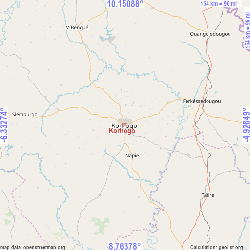
Korhogo GPS coordinates[2]
9° 27' 28.908" North, 5° 37' 46.596" West
| Map corner | latitude | longitude |
|---|---|---|
| Upper-left | 10.15088°, | -6.33274° |
| Center: | 9.45803°, | -5.62961° |
| Lower-right: | 8.76378°, | -4.92649° |
| Map W x H: | 154.2×154.2 km | = 95.8×95.8mi |
| max Lat: | 10.48115° ⇑12% North |
| Korhogo: | 9.45803° |
| min Lat: | ⇓88% South 4.42295° |
| min Long | Korhogo | max Long |
| -8.42592° | -5.62961° | -2.80003° |
| W 42.7%⇐ | ⇒57.3% E |
Elevation
Elevation of Korhogo is 360 m = 1181 ft, and this is 135.7 m = 445 ft above average elevation for this country.
| Max E: |
556 m = 1824 ft | 16.2% |
| Korhogo | 360 m 1181 ft | |
| Avg. | 224.3 m = 736 ft | |
Min E: |
7 m = 23 ft | 83.8% |
See also: Korhogo elevation on elevation.city.
Geographical zone
Korhogo is located in North Torrid zone (between Equator and Tropic of Cancer). Distance of Equator is 1051.6 km =653.4 mi to South.| Distance of | km | miles | from Korhogo |
|---|---|---|---|
| North Pole | 8955.4 | 5564.6 | to North |
| Arctic Circle | 6349.5 | 3945.4 | to North |
| Tropic Cancer | 1554.3 | 965.8 | to North |
| Equator | 1051.6 | 653.4 | to South |


Nearby cities:
15 places around Korhogo: (largest is in red/bold)
• Boundiali
94.3 km =58.6 mi,  274°
274°
• Dianra
89.4 km =55.6 mi,  230°
230°
• Dikodougou
46.1 km =28.6 mi,  199°
199°
• Ferkessédougou
50 km =31.1 mi,  72°
72°
• Kani
152.8 km =94.9 mi,  224°
224°
• Katiola
157.9 km =98.1 mi,  158°
158°
• Kong
117 km =72.7 mi,  107°
107°
• Kouto
98 km =60.9 mi,  299°
299°
• Madinani
144.9 km =90 mi,  276°
276°
• M’Bengué
67.4 km =41.9 mi,  333°
333°
• Niakaramandougou
96.5 km =60 mi, 157°
• Ouangolodougou
77.4 km =48.1 mi,  42°
42°
• Sinématiali
30.3 km =18.8 mi,  62°
62°
• Séguélon
164 km =101.9 mi, 266°
• Tengréla
142.1 km =88.3 mi,  323°
323°
Sources, notices
• [Note1] Compared only with cities in Ivory Coast existing in our database
• [Src1] Map data: © OpenStreetMap contributors (CC-BY-SA)
• [Src2] Other city data from geonames.org with taken over terms of usage.
• [Src3] Geographical zone / Annual Mean Temperature by Robert A. Rohde @ Wikipedia
