Ouangolodougou geodata
Ouangolodougou (Savanes) is a seat of a third-order administrative division; located in Ivory Coast in Africa/Abidjan (GMT+0) time zone. In our database, there are 63 cities with bigger population. Compared to other cities in Ivory Coast, 97.4% of cities are located further ↓South; 53.8% of cities are located further ←West and 74.4% of cities have lower elevation than Ouangolodougou. Note1


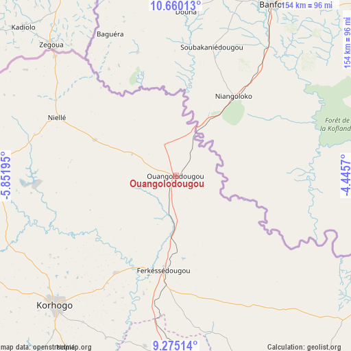
Ouangolodougou GPS coordinates[2]
9° 58' 6.132" North, 5° 8' 55.752" West
| Map corner | latitude | longitude |
|---|---|---|
| Upper-left | 10.66013°, | -5.85195° |
| Center: | 9.96837°, | -5.14882° |
| Lower-right: | 9.27514°, | -4.4457° |
| Map W x H: | 154×154 km | = 95.7×95.7mi |
| max Lat: | 10.48115° ⇑2.6% North |
| Ouangolodougou: | 9.96837° |
| min Lat: | ⇓97.4% South 4.42295° |
| min Long | Ouangolodougou | max Long |
| -8.42592° | -5.14882° | -2.80003° |
| W 53.8%⇐ | ⇒46.2% E |
Elevation
Elevation of Ouangolodougou is 328 m = 1076 ft, and this is 103.7 m = 340 ft above average elevation for this country.
| Max E: |
556 m = 1824 ft | 25.6% |
| Ouangolodougou | 328 m 1076 ft | |
| Avg. | 224.3 m = 736 ft | |
Min E: |
7 m = 23 ft | 74.4% |
See also: Ivory Coast elevation on elevation.city.
Geographical zone
Ouangolodougou is located in North Torrid zone (between Equator and Tropic of Cancer). Distance of Equator is 1108.4 km =688.7 mi to South.| Distance of | km | miles | from Ouangolodougou |
|---|---|---|---|
| North Pole | 8898.7 | 5529.4 | to North |
| Arctic Circle | 6292.8 | 3910.2 | to North |
| Tropic Cancer | 1497.5 | 930.5 | to North |
| Equator | 1108.4 | 688.7 | to South |


Nearby cities:
15 places around Ouangolodougou: (largest is in red/bold)
• Boundiali
154.8 km =96.2 mi,  251°
251°
• Dabakala
195.2 km =121.3 mi,  156°
156°
• Dianra
166.5 km =103.5 mi,  226°
226°
• Dikodougou
121.3 km =75.4 mi,  214°
214°
• Ferkessédougou
42.1 km =26.2 mi,  186°
186°
• Katiola
203.7 km =126.6 mi,  178°
178°
• Kong
108.6 km =67.5 mi,  147°
147°
• Korhogo
77.4 km =48.1 mi,  222°
222°
• Kouto
138.3 km =85.9 mi,  266°
266°
• Madinani
200.5 km =124.6 mi,  258°
258°
• M’Bengué
82.4 km =51.2 mi, 272°
• Niakaramandougou
146.6 km =91.1 mi, 186°
• Sinématiali
49.9 km =31 mi, 211°
• Tengréla
149 km =92.6 mi,  292°
292°
• Téhini
168.3 km =104.6 mi,  103°
103°
Sources, notices
• [Note1] Compared only with cities in Ivory Coast existing in our database
• [Src1] Map data: © OpenStreetMap contributors (CC-BY-SA)
• [Src2] Other city data from geonames.org with taken over terms of usage.
• [Src3] Geographical zone / Annual Mean Temperature by Robert A. Rohde @ Wikipedia
