Ferkessédougou geodata
Ferkessédougou (Savanes) is a seat of a second-order administrative division; located in Ivory Coast in Africa/Abidjan (GMT+0) time zone. With population of 62,008 people, there are 16 cities with bigger population in this country. Compared to other cities in Ivory Coast, 92.3% of cities are located further ↓South; 53% of cities are located further ←West and 76.9% of cities have lower elevation than Ferkessédougou. Note1


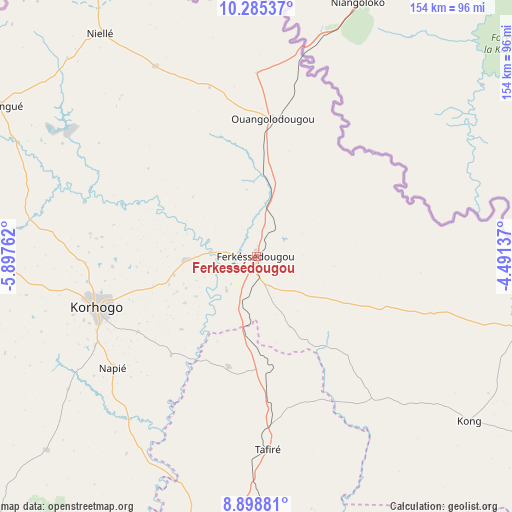
Ferkessédougou GPS coordinates[2]
9° 35' 34.08" North, 5° 11' 40.164" West
| Map corner | latitude | longitude |
|---|---|---|
| Upper-left | 10.28537°, | -5.89762° |
| Center: | 9.5928°, | -5.19449° |
| Lower-right: | 8.89881°, | -4.49137° |
| Map W x H: | 154.2×154.2 km | = 95.8×95.8mi |
| max Lat: | 10.48115° ⇑7.7% North |
| Ferkessédougou: | 9.5928° |
| min Lat: | ⇓92.3% South 4.42295° |
| min Long | Ferkessédougou | max Long |
| -8.42592° | -5.19449° | -2.80003° |
| W 53%⇐ | ⇒47% E |
Elevation
Elevation of Ferkessédougou is 334 m = 1096 ft, and this is 109.7 m = 360 ft above average elevation for this country.
| Max E: |
556 m = 1824 ft | 23.1% |
| Ferkessédougou | 334 m 1096 ft | |
| Avg. | 224.3 m = 736 ft | |
Min E: |
7 m = 23 ft | 76.9% |
See also: Ferkessédougou elevation on elevation.city.
Geographical zone
Ferkessédougou is located in North Torrid zone (between Equator and Tropic of Cancer). Distance of Equator is 1066.6 km =662.8 mi to South.| Distance of | km | miles | from Ferkessédougou |
|---|---|---|---|
| North Pole | 8940.4 | 5555.3 | to North |
| Arctic Circle | 6334.6 | 3936.1 | to North |
| Tropic Cancer | 1539.3 | 956.5 | to North |
| Equator | 1066.6 | 662.8 | to South |


Nearby cities:
15 places around Ferkessédougou: (largest is in red/bold)
• Boundiali
141.9 km =88.2 mi,  266°
266°
• Dabakala
160.5 km =99.7 mi,  148°
148°
• Dianra
137 km =85.1 mi,  238°
238°
• Dikodougou
86.2 km =53.6 mi,  227°
227°
• Katiola
162.2 km =100.8 mi,  176°
176°
• Kong
80.9 km =50.3 mi,  127°
127°
• Korhogo
50 km =31.1 mi,  252°
252°
• Kouto
137.2 km =85.3 mi,  283°
283°
• Madinani
191.6 km =119.1 mi, 270°
• M’Bengué
89.8 km =55.8 mi,  300°
300°
• Niakaramandougou
104.5 km =64.9 mi,  185°
185°
• Ouangolodougou
42.1 km =26.2 mi,  6°
6°
• Sinématiali
20.9 km =13 mi, 267°
• Tengréla
165.5 km =102.8 mi,  306°
306°
• Téhini
168.5 km =104.7 mi,  89°
89°
Sources, notices
• [Note1] Compared only with cities in Ivory Coast existing in our database
• [Src1] Map data: © OpenStreetMap contributors (CC-BY-SA)
• [Src2] Other city data from geonames.org with taken over terms of usage.
• [Src3] Geographical zone / Annual Mean Temperature by Robert A. Rohde @ Wikipedia
