Daloa geodata
Daloa (Sassandra-Marahoué) is a seat of a first-order administrative division; located in Ivory Coast in Africa/Abidjan (GMT+0) time zone. With population of 215,652 people, there are 3 cities with bigger population in this country. Compared to other cities in Ivory Coast, 50.4% of cities are located further ↑North; 70.9% of cities are located further →East and 61.5% of cities have lower elevation than Daloa. Note1


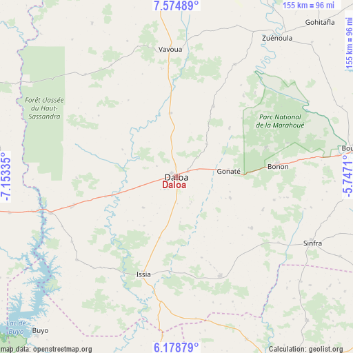
Daloa GPS coordinates[2]
6° 52' 38.46" North, 6° 27' 0.792" West
| Map corner | latitude | longitude |
|---|---|---|
| Upper-left | 7.57489°, | -7.15335° |
| Center: | 6.87735°, | -6.45022° |
| Lower-right: | 6.17879°, | -5.7471° |
| Map W x H: | 155.2×155.2 km | = 96.4×96.4mi |
| max Lat: | 10.48115° ⇑50.4% North |
| Daloa: | 6.87735° |
| min Lat: | ⇓49.6% South 4.42295° |
| min Long | Daloa | max Long |
| -8.42592° | -6.45022° | -2.80003° |
| W 29.1%⇐ | ⇒70.9% E |
Elevation
Elevation of Daloa is 262 m = 860 ft, and this is 37.7 m = 124 ft above average elevation for this country.
| Max E: |
556 m = 1824 ft | 38.5% |
| Daloa | 262 m 860 ft | |
| Avg. | 224.3 m = 736 ft | |
Min E: |
7 m = 23 ft | 61.5% |
See also: Daloa elevation on elevation.city.
Geographical zone
Daloa is located in North Torrid zone (between Equator and Tropic of Cancer). Distance of Equator is 764.7 km =475.2 mi to South.| Distance of | km | miles | from Daloa |
|---|---|---|---|
| North Pole | 9242.4 | 5743 | to North |
| Arctic Circle | 6636.5 | 4123.7 | to North |
| Tropic Cancer | 1841.2 | 1144.1 | to North |
| Equator | 764.7 | 475.2 | to South |


Nearby cities:
15 places around Daloa: (largest is in red/bold)
• Bangolo
115.3 km =71.6 mi,  277°
277°
• Bouaflé
78.9 km =49 mi,  80°
80°
• Buyo
90.2 km =56 mi,  222°
222°
• Duekoué
100.4 km =62.4 mi,  261°
261°
• Facobly
116.9 km =72.6 mi,  299°
299°
• Gagnoa
99.6 km =61.9 mi,  146°
146°
• Guibéroua
77.4 km =48.1 mi,  156°
156°
• Guiglo
121 km =75.2 mi,  252°
252°
• Issia
45.4 km =28.2 mi,  199°
199°
• Kouibly
96.3 km =59.8 mi, 295°
• Kounahiri
122.2 km =75.9 mi,  33°
33°
• Sinfra
66 km =41 mi,  115°
115°
• Vavoua
56.2 km =34.9 mi,  356°
356°
• Zoukougbeu
47.4 km =29.5 mi, 254°
• Zuénoula
75.7 km =47 mi,  35°
35°
Sources, notices
• [Note1] Compared only with cities in Ivory Coast existing in our database
• [Src1] Map data: © OpenStreetMap contributors (CC-BY-SA)
• [Src2] Other city data from geonames.org with taken over terms of usage.
• [Src3] Geographical zone / Annual Mean Temperature by Robert A. Rohde @ Wikipedia
