Issia geodata
Issia (Sassandra-Marahoué) is a seat of a third-order administrative division; located in Ivory Coast in Africa/Abidjan (GMT+0) time zone. With population of 50,313 people, there are 26 cities with bigger population in this country. Compared to other cities in Ivory Coast, 63.2% of cities are located further ↑North; 73.5% of cities are located further →East and 54.7% of cities have higher elevation than Issia. Note1


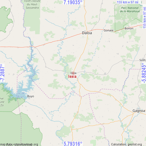
Issia GPS coordinates[2]
6° 29' 32.064" North, 6° 35' 8.088" West
| Map corner | latitude | longitude |
|---|---|---|
| Upper-left | 7.19035°, | -7.2887° |
| Center: | 6.49224°, | -6.58558° |
| Lower-right: | 5.79316°, | -5.88245° |
| Map W x H: | 155.4×155.4 km | = 96.6×96.6mi |
| max Lat: | 10.48115° ⇑63.2% North |
| Issia: | 6.49224° |
| min Lat: | ⇓36.8% South 4.42295° |
| min Long | Issia | max Long |
| -8.42592° | -6.58558° | -2.80003° |
| W 26.5%⇐ | ⇒73.5% E |
Elevation
Elevation of Issia is 211 m = 692 ft, and this is 13.3 m = 44 ft below average elevation for this country.
| Max E: |
556 m = 1824 ft | 54.7% |
| Avg. | 224.3 m = 736 ft | |
| Issia | 211 m = 692 ft | |
Min E: |
7 m = 23 ft | 45.3% |
See also: Issia elevation on elevation.city.
Geographical zone
Issia is located in North Torrid zone (between Equator and Tropic of Cancer). Distance of Equator is 721.9 km =448.6 mi to South.| Distance of | km | miles | from Issia |
|---|---|---|---|
| North Pole | 9285.2 | 5769.6 | to North |
| Arctic Circle | 6679.3 | 4150.3 | to North |
| Tropic Cancer | 1884 | 1170.7 | to North |
| Equator | 721.9 | 448.6 | to South |


Nearby cities:
15 places around Issia: (largest is in red/bold)
• Bangolo
115.1 km =71.5 mi,  300°
300°
• Bouaflé
108.2 km =67.2 mi,  59°
59°
• Buyo
51.5 km =32 mi,  242°
242°
• Daloa
45.4 km =28.2 mi,  19°
19°
• Duekoué
88.8 km =55.2 mi,  288°
288°
• Gagnoa
80.8 km =50.2 mi,  119°
119°
• Guibéroua
53.7 km =33.4 mi, 121°
• Guiglo
100.5 km =62.4 mi,  273°
273°
• Guéyo
106 km =65.9 mi,  147°
147°
• Kouibly
111.1 km =69 mi,  319°
319°
• Sinfra
75.8 km =47.1 mi,  79°
79°
• Soubré
78.8 km =49 mi,  180°
180°
• Taï
118.2 km =73.4 mi,  234°
234°
• Vavoua
99.6 km =61.9 mi,  6°
6°
• Zoukougbeu
43 km =26.7 mi,  314°
314°
Sources, notices
• [Note1] Compared only with cities in Ivory Coast existing in our database
• [Src1] Map data: © OpenStreetMap contributors (CC-BY-SA)
• [Src2] Other city data from geonames.org with taken over terms of usage.
• [Src3] Geographical zone / Annual Mean Temperature by Robert A. Rohde @ Wikipedia
