Loncoche geodata
Loncoche (Araucanía) is a populated place; located in Chile in America/Santiago (GMT-4) time zone. With population of 15,590 people, there are 94 cities with bigger population in this country. Compared to other cities in Chile, 75.2% of cities are located further ↑North; 72.4% of cities are located further →East and 54.5% of cities have higher elevation than Loncoche. Note1


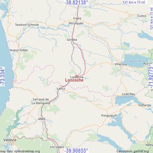
Loncoche GPS coordinates[2]
39° 22' 1.488" South, 72° 37' 51.132" West
| Map corner | latitude | longitude |
|---|---|---|
| Upper-left | -38.82138°, | -73.334° |
| Center: | -39.36708°, | -72.63087° |
| Lower-right: | -39.90855°, | -71.92775° |
| Map W x H: | 120.9×120.9 km | = 75.1×75.1mi |
| max Lat: | -18.19821° ⇑75.2% North |
| Loncoche: | -39.36708° |
| min Lat: | ⇓24.8% South -54.93355° |
| min Long | Loncoche | max Long |
| -109.42438° | -72.63087° | -67.60963° |
| W 27.6%⇐ | ⇒72.4% E |
Elevation
Elevation of Loncoche is 114 m = 374 ft, and this is 159 m = 522 ft below average elevation for this country.
| Max E: |
3544 m = 11627 ft | 54.5% |
| Avg. | 273 m = 896 ft | |
| Loncoche | 114 m = 374 ft | |
Min E: |
1 m = 3 ft | 45.5% |
See also: Chile elevation on elevation.city.
Geographical zone
Loncoche is located in South temperate zone (between Tropic of Capricorn and the Antarctic Circle). Distance of this Southern Tropic circle is 1771.3 km =1100.6 mi to North.| Distance of | km | miles | from Loncoche |
|---|---|---|---|
| Equator | 4377.2 | 2719.9 | to North |
| Tropic Capricorn | 1771.3 | 1100.6 | to North |
| Antarctic Circle | 3024 | 1879 | to South |
| South Pole | 5629.9 | 3498.3 | to South |


Nearby cities:
15 places around Loncoche: (largest is in red/bold)
• Carahue
86.1 km =53.5 mi,  327°
327°
• Corral
89.7 km =55.7 mi,  229°
229°
• Freire
46.1 km =28.6 mi,  0°
0°
• Las Animas
70.3 km =43.7 mi, 225°
• Las Gaviotas
73.2 km =45.5 mi,  220°
220°
• Nueva Imperial
74.5 km =46.3 mi,  338°
338°
• Panguipulli
40 km =24.9 mi,  140°
140°
• Pitrufquén
42.3 km =26.3 mi,  359°
359°
• Pucón
59 km =36.7 mi,  80°
80°
• Santa Rosa
90.2 km =56 mi,  176°
176°
• Temuco
69.8 km =43.4 mi, 2°
• Valdivia
72.4 km =45 mi, 226°
• Vilcún
85.2 km =52.9 mi,  24°
24°
• Villa Europa
73.7 km =45.8 mi, 224°
• Villarrica
35.8 km =22.2 mi, 75°
Sources, notices
• [Note1] Compared only with cities in Chile existing in our database
• [Src1] Map data: © OpenStreetMap contributors (CC-BY-SA)
• [Src2] Other city data from geonames.org with taken over terms of usage.
• [Src3] Geographical zone / Annual Mean Temperature by Robert A. Rohde @ Wikipedia
