Santa Rosa geodata
Santa Rosa (Los Ríos Region) is a populated locality; located in Chile in America/Santiago (GMT-4) time zone. With population of 1,000 people, there are 133 cities with bigger population in this country. Compared to other cities in Chile, 80% of cities are located further ↑North; 68.3% of cities are located further →East and 67.6% of cities have lower elevation than Santa Rosa. Note1


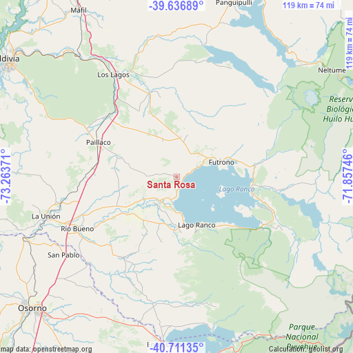
Santa Rosa GPS coordinates[2]
40° 10' 34.5" South, 72° 33' 38.088" West
| Map corner | latitude | longitude |
|---|---|---|
| Upper-left | -39.63689°, | -73.26371° |
| Center: | -40.17625°, | -72.56058° |
| Lower-right: | -40.71135°, | -71.85746° |
| Map W x H: | 119.5×119.5 km | = 74.3×74.3mi |
| max Lat: | -18.19821° ⇑80% North |
| Santa Rosa: | -40.17625° |
| min Lat: | ⇓20% South -54.93355° |
| min Long | Santa Rosa | max Long |
| -109.42438° | -72.56058° | -67.60963° |
| W 31.7%⇐ | ⇒68.3% E |
Elevation
Elevation of Santa Rosa is 239 m = 784 ft, and this is 34 m = 112 ft below average elevation for this country.
| Max E: |
3544 m = 11627 ft | 32.4% |
| Avg. | 273 m = 896 ft | |
| Santa Rosa | 239 m = 784 ft | |
Min E: |
1 m = 3 ft | 67.6% |
See also: Chile elevation on elevation.city.
Geographical zone
Santa Rosa is located in South temperate zone (between Tropic of Capricorn and the Antarctic Circle). Distance of this Southern Tropic circle is 1861.3 km =1156.6 mi to North.| Distance of | km | miles | from Santa Rosa |
|---|---|---|---|
| Equator | 4467.2 | 2775.8 | to North |
| Tropic Capricorn | 1861.3 | 1156.6 | to North |
| Antarctic Circle | 2934 | 1823.1 | to South |
| South Pole | 5539.9 | 3442.3 | to South |


Nearby cities:
15 places around Santa Rosa: (largest is in red/bold)
• Corral
80.8 km =50.2 mi,  293°
293°
• La Ensenada
114.7 km =71.3 mi,  179°
179°
• La Unión
46.1 km =28.6 mi,  253°
253°
• Las Animas
69.3 km =43.1 mi,  306°
306°
• Las Gaviotas
63.6 km =39.5 mi,  302°
302°
• Loncoche
90.2 km =56 mi,  356°
356°
• Osorno
65.7 km =40.8 mi,  227°
227°
• Panguipulli
62.3 km =38.7 mi,  18°
18°
• Pucón
112.1 km =69.7 mi,  27°
27°
• Purranque
96.3 km =59.8 mi,  211°
211°
• Puyehue
53.8 km =33.4 mi, 183°
• Río Bueno
37.9 km =23.5 mi,  242°
242°
• Valdivia
70.9 km =44.1 mi, 304°
• Villa Europa
68.6 km =42.6 mi, 303°
• Villarrica
103 km =64 mi, 16°
Sources, notices
• [Note1] Compared only with cities in Chile existing in our database
• [Src1] Map data: © OpenStreetMap contributors (CC-BY-SA)
• [Src2] Other city data from geonames.org with taken over terms of usage.
• [Src3] Geographical zone / Annual Mean Temperature by Robert A. Rohde @ Wikipedia
