Valdivia geodata
Valdivia (Los Ríos Region) is a seat of a first-order administrative division; located in Chile in America/Santiago (GMT-4) time zone. With population of 133,419 people, there are 20 cities with bigger population in this country. Compared to other cities in Chile, 77.2% of cities are located further ↑North; 92.4% of cities are located further →East and 90.3% of cities have higher elevation than Valdivia. Note1
Administrative division(s):
- Level 1: Los Ríos Region
- Level 2: Provincia de Valdivia
- Level 3: Valdivia


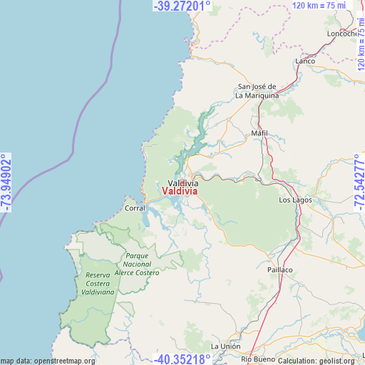
Valdivia GPS coordinates[2]
39° 48' 51.192" South, 73° 14' 45.204" West
| Map corner | latitude | longitude |
|---|---|---|
| Upper-left | -39.27201°, | -73.94902° |
| Center: | -39.81422°, | -73.24589° |
| Lower-right: | -40.35218°, | -72.54277° |
| Map W x H: | 120.1×120.1 km | = 74.6×74.6mi |
| max Lat: | -18.19821° ⇑77.2% North |
| Valdivia: | -39.81422° |
| min Lat: | ⇓22.8% South -54.93355° |
| min Long | Valdivia | max Long |
| -109.42438° | -73.24589° | -67.60963° |
| W 7.6%⇐ | ⇒92.4% E |
Elevation
Elevation of Valdivia is 17 m = 56 ft, and this is 256 m = 840 ft below average elevation for this country.
| Max E: |
3544 m = 11627 ft | 90.3% |
| Avg. | 273 m = 896 ft | |
| Valdivia | 17 m = 56 ft | |
Min E: |
1 m = 3 ft | 9.7% |
See also: Valdivia elevation on elevation.city.
Geographical zone
Valdivia is located in South temperate zone (between Tropic of Capricorn and the Antarctic Circle). Distance of this Southern Tropic circle is 1821 km =1131.5 mi to North.| Distance of | km | miles | from Valdivia |
|---|---|---|---|
| Equator | 4426.9 | 2750.7 | to North |
| Tropic Capricorn | 1821 | 1131.5 | to North |
| Antarctic Circle | 2974.2 | 1848.1 | to South |
| South Pole | 5580.1 | 3467.3 | to South |


Nearby cities:
15 places around Valdivia: (largest is in red/bold)
• Corral
17.8 km =11.1 mi,  242°
242°
• Freire
109.6 km =68.1 mi,  29°
29°
• La Unión
55.1 km =34.2 mi,  165°
165°
• Las Animas
2.4 km =1.5 mi,  75°
75°
• Las Gaviotas
7.6 km =4.7 mi,  139°
139°
• Loncoche
72.4 km =45 mi,  46°
46°
• Nueva Imperial
121.6 km =75.6 mi,  12°
12°
• Osorno
85 km =52.8 mi, 173°
• Panguipulli
80.4 km =50 mi, 76°
• Pitrufquén
105.9 km =65.8 mi, 29°
• Puyehue
108.7 km =67.5 mi,  149°
149°
• Río Bueno
62.9 km =39.1 mi,  156°
156°
• Santa Rosa
70.9 km =44.1 mi,  124°
124°
• Villa Europa
2.9 km =1.8 mi, 161°
• Villarrica
105.2 km =65.4 mi,  56°
56°
Sources, notices
• [Note1] Compared only with cities in Chile existing in our database
• [Src1] Map data: © OpenStreetMap contributors (CC-BY-SA)
• [Src2] Other city data from geonames.org with taken over terms of usage.
• [Src3] Geographical zone / Annual Mean Temperature by Robert A. Rohde @ Wikipedia
