Nueva Imperial geodata
Nueva Imperial (Araucanía) is a populated place; located in Chile in America/Santiago (GMT-4) time zone. With population of 18,777 people, there are 83 cities with bigger population in this country. Compared to other cities in Chile, 71.7% of cities are located further ↑North; 80% of cities are located further →East and 79.3% of cities have higher elevation than Nueva Imperial. Note1


Nueva Imperial GPS coordinates[2]
38° 44' 40.236" South, 72° 57' 0.9" West
| Map corner | latitude | longitude |
|---|---|---|
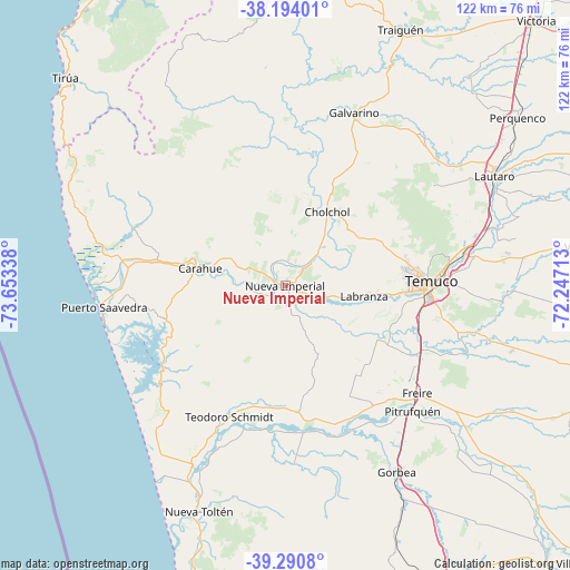
| Upper-left | -38.19401°, | -73.65338° |
| Center: | -38.74451°, | -72.95025° |
| Lower-right: | -39.2908°, | -72.24713° |
| Map W x H: | 122×122 km | = 75.8×75.8mi |
| max Lat: | -18.19821° ⇑71.7% North |
| Nueva Imperial: | -38.74451° |
| min Lat: | ⇓28.3% South -54.93355° |
| min Long | Nueva Imperial | max Long |
| -109.42438° | -72.95025° | -67.60963° |
| W 20%⇐ | ⇒80% E |
Elevation
Elevation of Nueva Imperial is 29 m = 95 ft, and this is 244 m = 801 ft below average elevation for this country.
| Max E: |
3544 m = 11627 ft | 79.3% |
| Avg. | 273 m = 896 ft | |
| Nueva Imperial | 29 m = 95 ft | |
Min E: |
1 m = 3 ft | 20.7% |
See also: Chile elevation on elevation.city.
Geographical zone
Nueva Imperial is located in South temperate zone (between Tropic of Capricorn and the Antarctic Circle). Distance of this Southern Tropic circle is 1702.1 km =1057.6 mi to North.| Distance of | km | miles | from Nueva Imperial |
|---|---|---|---|
| Equator | 4308 | 2676.9 | to North |
| Tropic Capricorn | 1702.1 | 1057.6 | to North |
| Antarctic Circle | 3093.2 | 1922 | to South |
| South Pole | 5699.1 | 3541.3 | to South |


Nearby cities:
15 places around Nueva Imperial: (largest is in red/bold)
• Angol
107.5 km =66.8 mi,  10°
10°
• Carahue
18.7 km =11.6 mi,  281°
281°
• Cañete
111.9 km =69.5 mi,  339°
339°
• Collipulli
98.7 km =61.3 mi,  27°
27°
• Freire
36.3 km =22.6 mi,  129°
129°
• Lautaro
50.6 km =31.4 mi,  61°
61°
• Loncoche
74.5 km =46.3 mi,  158°
158°
• Panguipulli
113.2 km =70.3 mi,  151°
151°
• Pitrufquén
38.2 km =23.7 mi, 134°
• Pucón
104.8 km =65.1 mi,  124°
124°
• Temuco
30.5 km =19 mi,  88°
88°
• Traiguén
60.2 km =37.4 mi,  23°
23°
• Victoria
78.2 km =48.6 mi,  43°
43°
• Vilcún
63.4 km =39.4 mi,  82°
82°
• Villarrica
86.7 km =53.9 mi, 133°
Sources, notices
• [Note1] Compared only with cities in Chile existing in our database
• [Src1] Map data: © OpenStreetMap contributors (CC-BY-SA)
• [Src2] Other city data from geonames.org with taken over terms of usage.
• [Src3] Geographical zone / Annual Mean Temperature by Robert A. Rohde @ Wikipedia
