Curanilahue geodata
Curanilahue (Biobío) is a populated place; located in Chile in America/Santiago (GMT-4) time zone. With population of 30,611 people, there are 55 cities with bigger population in this country. Compared to other cities in Chile, 62.8% of cities are located further ↑North; 93.8% of cities are located further →East and 51% of cities have lower elevation than Curanilahue. Note1


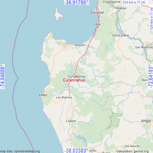
Curanilahue GPS coordinates[2]
37° 28' 40.548" South, 73° 20' 41.82" West
| Map corner | latitude | longitude |
|---|---|---|
| Upper-left | -36.91786°, | -74.04808° |
| Center: | -37.47793°, | -73.34495° |
| Lower-right: | -38.03383°, | -72.64183° |
| Map W x H: | 124.1×124.1 km | = 77.1×77.1mi |
| max Lat: | -18.19821° ⇑62.8% North |
| Curanilahue: | -37.47793° |
| min Lat: | ⇓37.2% South -54.93355° |
| min Long | Curanilahue | max Long |
| -109.42438° | -73.34495° | -67.60963° |
| W 6.2%⇐ | ⇒93.8% E |
Elevation
Elevation of Curanilahue is 141 m = 463 ft, and this is 132 m = 433 ft below average elevation for this country.
| Max E: |
3544 m = 11627 ft | 49% |
| Avg. | 273 m = 896 ft | |
| Curanilahue | 141 m = 463 ft | |
Min E: |
1 m = 3 ft | 51% |
See also: Chile elevation on elevation.city.
Geographical zone
Curanilahue is located in South temperate zone (between Tropic of Capricorn and the Antarctic Circle). Distance of this Southern Tropic circle is 1561.2 km =970.1 mi to North.| Distance of | km | miles | from Curanilahue |
|---|---|---|---|
| Equator | 4167.2 | 2589.4 | to North |
| Tropic Capricorn | 1561.2 | 970.1 | to North |
| Antarctic Circle | 3234 | 2009.5 | to South |
| South Pole | 5839.9 | 3628.7 | to South |


Nearby cities:
15 places around Curanilahue: (largest is in red/bold)
• Angol
65.6 km =40.8 mi,  122°
122°
• Arauco
25.9 km =16.1 mi,  5°
5°
• Cañete
36.2 km =22.5 mi,  187°
187°
• Chiguayante
67.5 km =41.9 mi,  24°
24°
• Collipulli
96 km =59.7 mi, 123°
• Concepción
77 km =47.8 mi, 19°
• Coronel
52.6 km =32.7 mi, 20°
• Laja
60 km =37.3 mi,  68°
68°
• Lebu
30.8 km =19.1 mi,  241°
241°
• Los Ángeles
87.5 km =54.4 mi,  89°
89°
• Lota
46.2 km =28.7 mi, 21°
• Nacimiento
59.3 km =36.8 mi, 92°
• Penco
87.6 km =54.4 mi, 20°
• Talcahuano
86.1 km =53.5 mi, 13°
• Yumbel
81.2 km =50.5 mi,  58°
58°
Sources, notices
• [Note1] Compared only with cities in Chile existing in our database
• [Src1] Map data: © OpenStreetMap contributors (CC-BY-SA)
• [Src2] Other city data from geonames.org with taken over terms of usage.
• [Src3] Geographical zone / Annual Mean Temperature by Robert A. Rohde @ Wikipedia
