Penco geodata
Penco (Biobío) is a populated place; located in Chile in America/Santiago (GMT-4) time zone. With population of 46,091 people, there are 43 cities with bigger population in this country. Compared to other cities in Chile, 55.2% of cities are located further ↑North; 82.8% of cities are located further →East and 83.4% of cities have higher elevation than Penco. Note1


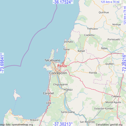
Penco GPS coordinates[2]
36° 44' 26.7" South, 72° 59' 43.008" West
| Map corner | latitude | longitude |
|---|---|---|
| Upper-left | -36.17524°, | -73.69841° |
| Center: | -36.74075°, | -72.99528° |
| Lower-right: | -37.30213°, | -72.29216° |
| Map W x H: | 125.3×125.3 km | = 77.9×77.9mi |
| max Lat: | -18.19821° ⇑55.2% North |
| Penco: | -36.74075° |
| min Lat: | ⇓44.8% South -54.93355° |
| min Long | Penco | max Long |
| -109.42438° | -72.99528° | -67.60963° |
| W 17.2%⇐ | ⇒82.8% E |
Elevation
Elevation of Penco is 24 m = 79 ft, and this is 249 m = 817 ft below average elevation for this country.
| Max E: |
3544 m = 11627 ft | 83.4% |
| Avg. | 273 m = 896 ft | |
| Penco | 24 m = 79 ft | |
Min E: |
1 m = 3 ft | 16.6% |
See also: Penco elevation on elevation.city.
Geographical zone
Penco is located in South temperate zone (between Tropic of Capricorn and the Antarctic Circle). Distance of this Southern Tropic circle is 1479.3 km =919.2 mi to North.| Distance of | km | miles | from Penco |
|---|---|---|---|
| Equator | 4085.2 | 2538.4 | to North |
| Tropic Capricorn | 1479.3 | 919.2 | to North |
| Antarctic Circle | 3316 | 2060.5 | to South |
| South Pole | 5921.9 | 3679.7 | to South |


Nearby cities:
15 places around Penco: (largest is in red/bold)
• Arauco
63.1 km =39.2 mi,  206°
206°
• Bulnes
62.1 km =38.6 mi,  90°
90°
• Cabrero
61.8 km =38.4 mi,  121°
121°
• Chiguayante
20.8 km =12.9 mi,  188°
188°
• Chillán
80.9 km =50.3 mi,  79°
79°
• Concepción
10.7 km =6.6 mi, 206°
• Coronel
35 km =21.7 mi,  201°
201°
• Curanilahue
87.6 km =54.4 mi, 200°
• Laja
65.5 km =40.7 mi,  157°
157°
• Lota
41.4 km =25.7 mi, 200°
• Nacimiento
89.4 km =55.6 mi, 161°
• Quirihue
65.4 km =40.6 mi,  38°
38°
• Talcahuano
11 km =6.8 mi,  279°
279°
• Tomé
14.1 km =8.8 mi,  14°
14°
• Yumbel
55.4 km =34.4 mi,  135°
135°
Sources, notices
• [Note1] Compared only with cities in Chile existing in our database
• [Src1] Map data: © OpenStreetMap contributors (CC-BY-SA)
• [Src2] Other city data from geonames.org with taken over terms of usage.
• [Src3] Geographical zone / Annual Mean Temperature by Robert A. Rohde @ Wikipedia
