Cañete geodata
Cañete (Biobío) is a populated place; located in Chile in America/Santiago (GMT-4) time zone. With population of 20,158 people, there are 81 cities with bigger population in this country. Compared to other cities in Chile, 66.2% of cities are located further ↑North; 94.5% of cities are located further →East and 64.1% of cities have higher elevation than Cañete. Note1


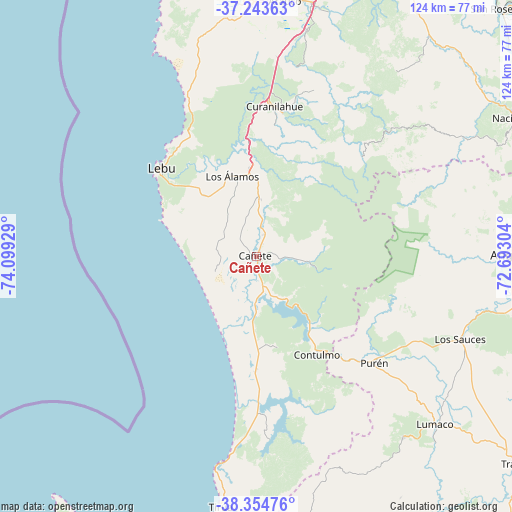
Cañete GPS coordinates[2]
37° 48' 4.608" South, 73° 23' 46.176" West
| Map corner | latitude | longitude |
|---|---|---|
| Upper-left | -37.24363°, | -74.09929° |
| Center: | -37.80128°, | -73.39616° |
| Lower-right: | -38.35476°, | -72.69304° |
| Map W x H: | 123.5×123.5 km | = 76.7×76.7mi |
| max Lat: | -18.19821° ⇑66.2% North |
| Cañete: | -37.80128° |
| min Lat: | ⇓33.8% South -54.93355° |
| min Long | Cañete | max Long |
| -109.42438° | -73.39616° | -67.60963° |
| W 5.5%⇐ | ⇒94.5% E |
Elevation
Elevation of Cañete is 69 m = 226 ft, and this is 204 m = 669 ft below average elevation for this country.
| Max E: |
3544 m = 11627 ft | 64.1% |
| Avg. | 273 m = 896 ft | |
| Cañete | 69 m = 226 ft | |
Min E: |
1 m = 3 ft | 35.9% |
See also: Chile elevation on elevation.city.
Geographical zone
Cañete is located in South temperate zone (between Tropic of Capricorn and the Antarctic Circle). Distance of this Southern Tropic circle is 1597.2 km =992.5 mi to North.| Distance of | km | miles | from Cañete |
|---|---|---|---|
| Equator | 4203.1 | 2611.7 | to North |
| Tropic Capricorn | 1597.2 | 992.5 | to North |
| Antarctic Circle | 3198.1 | 1987.2 | to South |
| South Pole | 5804 | 3606.4 | to South |


Nearby cities:
15 places around Cañete: (largest is in red/bold)
• Angol
59.7 km =37.1 mi,  89°
89°
• Arauco
62.1 km =38.6 mi,  6°
6°
• Carahue
103.2 km =64.1 mi,  168°
168°
• Chiguayante
102.6 km =63.8 mi,  18°
18°
• Collipulli
86.1 km =53.5 mi,  101°
101°
• Coronel
88.3 km =54.9 mi, 14°
• Curanilahue
36.2 km =22.5 mi, 7°
• Laja
83.4 km =51.8 mi,  46°
46°
• Lebu
31.2 km =19.4 mi,  313°
313°
• Los Ángeles
98.9 km =61.5 mi,  68°
68°
• Lota
81.8 km =50.8 mi, 14°
• Mulchén
102 km =63.4 mi,  84°
84°
• Nacimiento
71.8 km =44.6 mi,  62°
62°
• Traiguén
80.8 km =50.2 mi,  128°
128°
• Victoria
104.8 km =65.1 mi,  117°
117°
Sources, notices
• [Note1] Compared only with cities in Chile existing in our database
• [Src1] Map data: © OpenStreetMap contributors (CC-BY-SA)
• [Src2] Other city data from geonames.org with taken over terms of usage.
• [Src3] Geographical zone / Annual Mean Temperature by Robert A. Rohde @ Wikipedia
