Talcahuano geodata
Talcahuano (Biobío) is a populated place; located in Chile in America/Santiago (GMT-4) time zone. With population of 252,968 people, there are 5 cities with bigger population in this country. Compared to other cities in Chile, 54.5% of cities are located further ↑North; 85.5% of cities are located further →East and 92.4% of cities have higher elevation than Talcahuano. Note1
Administrative division(s):
- Level 1: Biobío
- Level 2: Provincia de Concepción
- Level 3: Comuna de Talcahuano


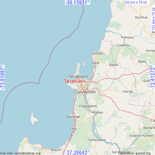
Talcahuano GPS coordinates[2]
36° 43' 29.784" South, 73° 7' 0.624" West
| Map corner | latitude | longitude |
|---|---|---|
| Upper-left | -36.15931°, | -73.81997° |
| Center: | -36.72494°, | -73.11684° |
| Lower-right: | -37.28643°, | -72.41372° |
| Map W x H: | 125.3×125.3 km | = 77.9×77.9mi |
| max Lat: | -18.19821° ⇑54.5% North |
| Talcahuano: | -36.72494° |
| min Lat: | ⇓45.5% South -54.93355° |
| min Long | Talcahuano | max Long |
| -109.42438° | -73.11684° | -67.60963° |
| W 14.5%⇐ | ⇒85.5% E |
Elevation
Elevation of Talcahuano is 15 m = 49 ft, and this is 258 m = 846 ft below average elevation for this country.
| Max E: |
3544 m = 11627 ft | 92.4% |
| Avg. | 273 m = 896 ft | |
| Talcahuano | 15 m = 49 ft | |
Min E: |
1 m = 3 ft | 7.6% |
See also: Talcahuano elevation on elevation.city.
Geographical zone
Talcahuano is located in South temperate zone (between Tropic of Capricorn and the Antarctic Circle). Distance of this Southern Tropic circle is 1477.5 km =918.1 mi to North.| Distance of | km | miles | from Talcahuano |
|---|---|---|---|
| Equator | 4083.4 | 2537.3 | to North |
| Tropic Capricorn | 1477.5 | 918.1 | to North |
| Antarctic Circle | 3317.7 | 2061.5 | to South |
| South Pole | 5923.6 | 3680.8 | to South |


Nearby cities:
15 places around Talcahuano: (largest is in red/bold)
• Arauco
60.6 km =37.7 mi,  197°
197°
• Bulnes
72.9 km =45.3 mi,  91°
91°
• Cabrero
72.1 km =44.8 mi,  118°
118°
• Chiguayante
23.7 km =14.7 mi,  160°
160°
• Chillán
91.3 km =56.7 mi,  81°
81°
• Concepción
12.8 km =8 mi,  152°
152°
• Coronel
34.4 km =21.4 mi,  183°
183°
• Curanilahue
86.1 km =53.5 mi,  193°
193°
• Laja
71.9 km =44.7 mi, 149°
• Lota
40.7 km =25.3 mi, 185°
• Nacimiento
95 km =59 mi, 155°
• Penco
11 km =6.8 mi,  99°
99°
• Quirihue
71.4 km =44.4 mi,  46°
46°
• Tomé
18.7 km =11.6 mi, 50°
• Yumbel
64.5 km =40.1 mi,  130°
130°
Sources, notices
• [Note1] Compared only with cities in Chile existing in our database
• [Src1] Map data: © OpenStreetMap contributors (CC-BY-SA)
• [Src2] Other city data from geonames.org with taken over terms of usage.
• [Src3] Geographical zone / Annual Mean Temperature by Robert A. Rohde @ Wikipedia
