Angol geodata
Angol (Araucanía) is a seat of a second-order administrative division; located in Chile in America/Santiago (GMT-4) time zone. With population of 44,856 people, there are 46 cities with bigger population in this country. Compared to other cities in Chile, 65.5% of cities are located further ↑North; 77.9% of cities are located further →East and 59.3% of cities have higher elevation than Angol. Note1


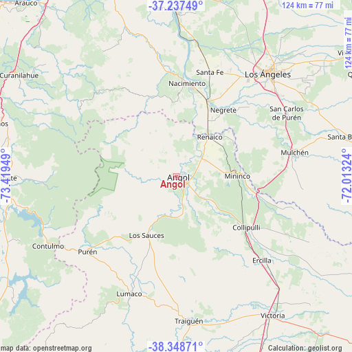
Angol GPS coordinates[2]
37° 47' 42.684" South, 72° 42' 58.896" West
| Map corner | latitude | longitude |
|---|---|---|
| Upper-left | -37.23749°, | -73.41949° |
| Center: | -37.79519°, | -72.71636° |
| Lower-right: | -38.34871°, | -72.01324° |
| Map W x H: | 123.6×123.6 km | = 76.8×76.8mi |
| max Lat: | -18.19821° ⇑65.5% North |
| Angol: | -37.79519° |
| min Lat: | ⇓34.5% South -54.93355° |
| min Long | Angol | max Long |
| -109.42438° | -72.71636° | -67.60963° |
| W 22.1%⇐ | ⇒77.9% E |
Elevation
Elevation of Angol is 101 m = 331 ft, and this is 172 m = 564 ft below average elevation for this country.
| Max E: |
3544 m = 11627 ft | 59.3% |
| Avg. | 273 m = 896 ft | |
| Angol | 101 m = 331 ft | |
Min E: |
1 m = 3 ft | 40.7% |
See also: Angol elevation on elevation.city.
Geographical zone
Angol is located in South temperate zone (between Tropic of Capricorn and the Antarctic Circle). Distance of this Southern Tropic circle is 1596.5 km =992 mi to North.| Distance of | km | miles | from Angol |
|---|---|---|---|
| Equator | 4202.4 | 2611.2 | to North |
| Tropic Capricorn | 1596.5 | 992 | to North |
| Antarctic Circle | 3198.7 | 1987.6 | to South |
| South Pole | 5804.6 | 3606.8 | to South |


Nearby cities:
15 places around Angol: (largest is in red/bold)
• Arauco
80.8 km =50.2 mi,  319°
319°
• Cabrero
89 km =55.3 mi,  18°
18°
• Cañete
59.7 km =37.1 mi,  269°
269°
• Collipulli
30.4 km =18.9 mi,  125°
125°
• Curanilahue
65.6 km =40.8 mi,  302°
302°
• Laja
56.8 km =35.3 mi,  0°
0°
• Lautaro
85.4 km =53.1 mi,  163°
163°
• Lebu
85 km =52.8 mi,  284°
284°
• Los Ángeles
48.3 km =30 mi,  41°
41°
• Lota
87.6 km =54.4 mi,  333°
333°
• Mulchén
42.6 km =26.5 mi,  78°
78°
• Nacimiento
32.8 km =20.4 mi,  6°
6°
• Traiguén
50.7 km =31.5 mi,  175°
175°
• Victoria
59.1 km =36.7 mi,  145°
145°
• Yumbel
78.7 km =48.9 mi, 10°
Sources, notices
• [Note1] Compared only with cities in Chile existing in our database
• [Src1] Map data: © OpenStreetMap contributors (CC-BY-SA)
• [Src2] Other city data from geonames.org with taken over terms of usage.
• [Src3] Geographical zone / Annual Mean Temperature by Robert A. Rohde @ Wikipedia
