Lebu geodata
Lebu (Biobío) is a seat of a second-order administrative division; located in Chile in America/Santiago (GMT-4) time zone. With population of 22,345 people, there are 76 cities with bigger population in this country. Compared to other cities in Chile, 64.1% of cities are located further ↑North; 97.2% of cities are located further →East and 95.2% of cities have higher elevation than Lebu. Note1


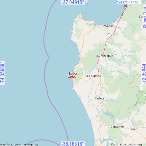
Lebu GPS coordinates[2]
37° 36' 29.7" South, 73° 39' 12.816" West
| Map corner | latitude | longitude |
|---|---|---|
| Upper-left | -37.04915°, | -74.35669° |
| Center: | -37.60825°, | -73.65356° |
| Lower-right: | -38.16318°, | -72.95044° |
| Map W x H: | 123.9×123.9 km | = 77×77mi |
| max Lat: | -18.19821° ⇑64.1% North |
| Lebu: | -37.60825° |
| min Lat: | ⇓35.9% South -54.93355° |
| min Long | Lebu | max Long |
| -109.42438° | -73.65356° | -67.60963° |
| W 2.8%⇐ | ⇒97.2% E |
Elevation
Elevation of Lebu is 12 m = 39 ft, and this is 261 m = 856 ft below average elevation for this country.
| Max E: |
3544 m = 11627 ft | 95.2% |
| Avg. | 273 m = 896 ft | |
| Lebu | 12 m = 39 ft | |
Min E: |
1 m = 3 ft | 4.8% |
See also: Chile elevation on elevation.city.
Geographical zone
Lebu is located in South temperate zone (between Tropic of Capricorn and the Antarctic Circle). Distance of this Southern Tropic circle is 1575.7 km =979.1 mi to North.| Distance of | km | miles | from Lebu |
|---|---|---|---|
| Equator | 4181.6 | 2598.3 | to North |
| Tropic Capricorn | 1575.7 | 979.1 | to North |
| Antarctic Circle | 3219.5 | 2000.5 | to South |
| South Pole | 5825.4 | 3619.7 | to South |


Nearby cities:
15 places around Lebu: (largest is in red/bold)
• Angol
85 km =52.8 mi,  104°
104°
• Arauco
50 km =31.1 mi,  36°
36°
• Cañete
31.2 km =19.4 mi,  133°
133°
• Chiguayante
93.9 km =58.3 mi, 36°
• Collipulli
113.8 km =70.7 mi,  109°
109°
• Concepción
102 km =63.4 mi,  31°
31°
• Coronel
78.4 km =48.7 mi, 35°
• Curanilahue
30.8 km =19.1 mi,  61°
61°
• Laja
90.7 km =56.4 mi,  66°
66°
• Lota
72.4 km =45 mi, 37°
• Nacimiento
87.2 km =54.2 mi,  82°
82°
• Penco
112.7 km =70 mi, 31°
• Talcahuano
109.1 km =67.8 mi, 25°
• Traiguén
111.9 km =69.5 mi, 129°
• Yumbel
112 km =69.6 mi, 59°
Sources, notices
• [Note1] Compared only with cities in Chile existing in our database
• [Src1] Map data: © OpenStreetMap contributors (CC-BY-SA)
• [Src2] Other city data from geonames.org with taken over terms of usage.
• [Src3] Geographical zone / Annual Mean Temperature by Robert A. Rohde @ Wikipedia
