Victoria geodata
Victoria (Araucanía) is a populated place; located in Chile in America/Santiago (GMT-4) time zone. With population of 24,555 people, there are 69 cities with bigger population in this country. Compared to other cities in Chile, 67.6% of cities are located further ↑North; 61.4% of cities are located further →East and 78.6% of cities have lower elevation than Victoria. Note1


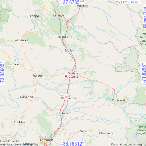
Victoria GPS coordinates[2]
38° 13' 58.476" South, 72° 19' 58.512" West
| Map corner | latitude | longitude |
|---|---|---|
| Upper-left | -37.67851°, | -73.03605° |
| Center: | -38.23291°, | -72.33292° |
| Lower-right: | -38.78312°, | -71.6298° |
| Map W x H: | 122.8×122.8 km | = 76.3×76.3mi |
| max Lat: | -18.19821° ⇑67.6% North |
| Victoria: | -38.23291° |
| min Lat: | ⇓32.4% South -54.93355° |
| min Long | Victoria | max Long |
| -109.42438° | -72.33292° | -67.60963° |
| W 38.6%⇐ | ⇒61.4% E |
Elevation
Elevation of Victoria is 355 m = 1165 ft, and this is 82 m = 269 ft above average elevation for this country.
| Max E: |
3544 m = 11627 ft | 21.4% |
| Victoria | 355 m 1165 ft | |
| Avg. | 273 m = 896 ft | |
Min E: |
1 m = 3 ft | 78.6% |
See also: Chile elevation on elevation.city.
Geographical zone
Victoria is located in South temperate zone (between Tropic of Capricorn and the Antarctic Circle). Distance of this Southern Tropic circle is 1645.2 km =1022.3 mi to North.| Distance of | km | miles | from Victoria |
|---|---|---|---|
| Equator | 4251.1 | 2641.5 | to North |
| Tropic Capricorn | 1645.2 | 1022.3 | to North |
| Antarctic Circle | 3150.1 | 1957.4 | to South |
| South Pole | 5756 | 3576.6 | to South |


Nearby cities:
15 places around Victoria: (largest is in red/bold)
• Angol
59.1 km =36.7 mi,  325°
325°
• Carahue
89.6 km =55.7 mi,  233°
233°
• Cañete
104.8 km =65.1 mi,  297°
297°
• Collipulli
32.2 km =20 mi,  343°
343°
• Freire
84 km =52.2 mi,  197°
197°
• Laja
110.6 km =68.7 mi, 342°
• Lautaro
34.3 km =21.3 mi, 195°
• Los Ángeles
84.9 km =52.8 mi,  358°
358°
• Mulchén
57.7 km =35.9 mi,  8°
8°
• Nacimiento
86.5 km =53.7 mi, 339°
• Nueva Imperial
78.2 km =48.6 mi,  223°
223°
• Pitrufquén
87.8 km =54.6 mi, 197°
• Temuco
60.9 km =37.8 mi, 202°
• Traiguén
29.5 km =18.3 mi,  266°
266°
• Vilcún
49.4 km =30.7 mi,  169°
169°
Sources, notices
• [Note1] Compared only with cities in Chile existing in our database
• [Src1] Map data: © OpenStreetMap contributors (CC-BY-SA)
• [Src2] Other city data from geonames.org with taken over terms of usage.
• [Src3] Geographical zone / Annual Mean Temperature by Robert A. Rohde @ Wikipedia
