Akonolinga geodata
Akonolinga (Centre) is a populated place; located in Cameroon in Africa/Douala (GMT+1) time zone. With population of 17,181 people, there are 60 cities with bigger population in this country. Compared to other cities in Cameroon, 88.5% of cities are located further ↑North; 69.7% of cities are located further ←West and 52.5% of cities have lower elevation than Akonolinga. Note1


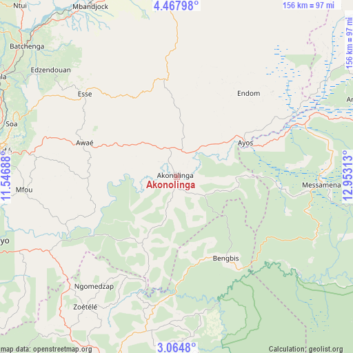
Akonolinga GPS coordinates[2]
3° 46' 0.012" North, 12° 15' 0" East
| Map corner | latitude | longitude |
|---|---|---|
| Upper-left | 4.46798°, | 11.54688° |
| Center: | 3.76667°, | 12.25° |
| Lower-right: | 3.0648°, | 12.95313° |
| Map W x H: | 156×156 km | = 96.9×96.9mi |
| max Lat: | 12.57535° ⇑88.5% North |
| Akonolinga: | 3.76667° |
| min Lat: | ⇓11.5% South 2.35° |
| min Long | Akonolinga | max Long |
| 8.8724° | 12.25° | 15.23288° |
| W 69.7%⇐ | ⇒30.3% E |
Elevation
Elevation of Akonolinga is 643 m = 2110 ft, and this is 30.9 m = 101 ft below average elevation for this country.
| Max E: |
1687 m = 5535 ft | 47.5% |
| Avg. | 673.9 m = 2211 ft | |
| Akonolinga | 643 m = 2110 ft | |
Min E: |
1 m = 3 ft | 52.5% |
See also: Cameroon elevation on elevation.city.
Geographical zone
Akonolinga is located in North Torrid zone (between Equator and Tropic of Cancer). Distance of Equator is 418.8 km =260.2 mi to South.| Distance of | km | miles | from Akonolinga |
|---|---|---|---|
| North Pole | 9588.2 | 5957.8 | to North |
| Arctic Circle | 6982.4 | 4338.7 | to North |
| Tropic Cancer | 2187.1 | 1359 | to North |
| Equator | 418.8 | 260.2 | to South |


Nearby cities:
15 places around Akonolinga: (largest is in red/bold)
• Abong Mbang
106.3 km =66.1 mi,  76°
76°
• Akono
106 km =65.9 mi,  253°
253°
• Essé
53.7 km =33.4 mi,  313°
313°
• Mbalmayo
87.7 km =54.5 mi, 251°
• Mbandjok
85.3 km =53 mi,  332°
332°
• Mbankomo
96.2 km =59.8 mi,  271°
271°
• Minta
109.4 km =68 mi,  33°
33°
• Nanga Eboko
102.7 km =63.8 mi,  7°
7°
• Nkoteng
86.8 km =53.9 mi,  343°
343°
• Ntui
102.2 km =63.5 mi,  318°
318°
• Obala
91.1 km =56.6 mi,  299°
299°
• Okoa
76 km =47.2 mi,  288°
288°
• Okola
100.1 km =62.2 mi, 286°
• Sangmélima
97.3 km =60.5 mi,  197°
197°
• Yaoundé
82.1 km =51 mi,  277°
277°
Sources, notices
• [Note1] Compared only with cities in Cameroon existing in our database
• [Src1] Map data: © OpenStreetMap contributors (CC-BY-SA)
• [Src2] Other city data from geonames.org with taken over terms of usage.
• [Src3] Geographical zone / Annual Mean Temperature by Robert A. Rohde @ Wikipedia
