Tonga geodata
Tonga (West) is a populated place; located in Cameroon in Africa/Douala (GMT+1) time zone. With population of 16,036 people, there are 62 cities with bigger population in this country. Compared to other cities in Cameroon, 51.6% of cities are located further ↓South; 54.9% of cities are located further →East and 68.9% of cities have lower elevation than Tonga. Note1


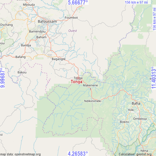
Tonga GPS coordinates[2]
4° 58' 0.012" North, 10° 42' 0" East
| Map corner | latitude | longitude |
|---|---|---|
| Upper-left | 5.66677°, | 9.99687° |
| Center: | 4.96667°, | 10.7° |
| Lower-right: | 4.26583°, | 11.40313° |
| Map W x H: | 155.8×155.8 km | = 96.8×96.8mi |
| max Lat: | 12.57535° ⇑48.4% North |
| Tonga: | 4.96667° |
| min Lat: | ⇓51.6% South 2.35° |
| min Long | Tonga | max Long |
| 8.8724° | 10.7° | 15.23288° |
| W 45.1%⇐ | ⇒54.9% E |
Elevation
Elevation of Tonga is 809 m = 2654 ft, and this is 135.1 m = 443 ft above average elevation for this country.
| Max E: |
1687 m = 5535 ft | 31.1% |
| Tonga | 809 m 2654 ft | |
| Avg. | 673.9 m = 2211 ft | |
Min E: |
1 m = 3 ft | 68.9% |
See also: Cameroon elevation on elevation.city.
Geographical zone
Tonga is located in North Torrid zone (between Equator and Tropic of Cancer). Distance of Equator is 552.2 km =343.1 mi to South.| Distance of | km | miles | from Tonga |
|---|---|---|---|
| North Pole | 9454.8 | 5874.9 | to North |
| Arctic Circle | 6848.9 | 4255.7 | to North |
| Tropic Cancer | 2053.7 | 1276.1 | to North |
| Equator | 552.2 | 343.1 | to South |


Nearby cities:
15 places around Tonga: (largest is in red/bold)
• Bafang
61.7 km =38.3 mi,  290°
290°
• Bafia
63.8 km =39.6 mi,  112°
112°
• Bafoussam
64.9 km =40.3 mi,  331°
331°
• Bamendjou
62.4 km =38.8 mi,  318°
318°
• Bana
51.1 km =31.8 mi, 293°
• Bandjoun
55.5 km =34.5 mi, 325°
• Bangangté
27.4 km =17 mi, 315°
• Bansoa
68.6 km =42.6 mi, 321°
• Bazou
27.8 km =17.3 mi, 291°
• Foumbot
60.7 km =37.7 mi,  352°
352°
• Ndikiniméki
26.7 km =16.6 mi,  146°
146°
• Ngambé
82.1 km =51 mi,  186°
186°
• Ngoro
75.7 km =47 mi,  91°
91°
• Ngou
43.2 km =26.8 mi,  306°
306°
• Ombésa
73.3 km =45.5 mi,  123°
123°
Sources, notices
• [Note1] Compared only with cities in Cameroon existing in our database
• [Src1] Map data: © OpenStreetMap contributors (CC-BY-SA)
• [Src2] Other city data from geonames.org with taken over terms of usage.
• [Src3] Geographical zone / Annual Mean Temperature by Robert A. Rohde @ Wikipedia
